


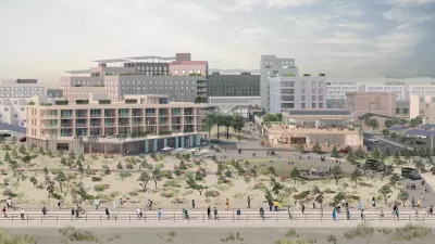
Has New York done enough to continue to build new high-end buildings in flood zones around the city?
According to an article by Kyle Chayka, "for all the talk of big changes to our waterside metropolis post-Sandy, the three years since then have been a Category 5 storm in terms of real-estate development."
Development in flood zones can be found all over the city, according to Chayka:
"Luxurious new buildings are popping up in flood zones all around the city precisely in the spots that Hurricane Sandy hit the hardest. And even vulnerable-seeming areas didn't see the expected slowdown. From the western edge of Chelsea and swaths of the Hudson Yards complex to the nautical-industrial streets of Red Hook, we’re building up in New York’s environmental weak spots — often the areas that were, long ago, swampland."
Chayka goes on to list a case-by-case set of examples of new developments located in flood zones—all of which fit the description of big New York money, whether the use is residential, entertainment, or office.
One point made in the article is that the city will soon build new infrastructure "like the Dry Line, a $335 million proposal to build a two-mile-long, 15-foot-high flood wall running along the Lower East Side, along with some knolls and landscaped parks." Unmentioned, however, but brought up by @MarketUrbanism on Twitter, is how each one of these buildings has designed its site and systems to repel the inevitable deluge.
FULL STORY: Developers Keep Building in Sandy Flood Zones


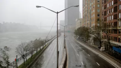
In Battery Park City, Public Infrastructure Meets Climate Resilience
A massive project underway in Lower Manhattan seeks to protect the shoreline from future flooding and mitigate the effects of climate change and rising sea levels.
Net Zero Development Coming to New York City
The project, which relies largely on geothermal energy to minimize its carbon footprint, will bring affordable housing and boost storm resilience to an area devastated by Hurricane Sandy.
Saving Lower Manhattan
A debate over how to protect the East River waterfront from Sandy-level flooding and storm damage has delayed the project as community activists decry the city's last-minute change of plans.

Planetizen Federal Action Tracker
A weekly monitor of how Trump’s orders and actions are impacting planners and planning in America.

Maui's Vacation Rental Debate Turns Ugly
Verbal attacks, misinformation campaigns and fistfights plague a high-stakes debate to convert thousands of vacation rentals into long-term housing.

Restaurant Patios Were a Pandemic Win — Why Were They so Hard to Keep?
Social distancing requirements and changes in travel patterns prompted cities to pilot new uses for street and sidewalk space. Then it got complicated.

In California Battle of Housing vs. Environment, Housing Just Won
A new state law significantly limits the power of CEQA, an environmental review law that served as a powerful tool for blocking new development.

Boulder Eliminates Parking Minimums Citywide
Officials estimate the cost of building a single underground parking space at up to $100,000.

Orange County, Florida Adopts Largest US “Sprawl Repair” Code
The ‘Orange Code’ seeks to rectify decades of sprawl-inducing, car-oriented development.
Urban Design for Planners 1: Software Tools
This six-course series explores essential urban design concepts using open source software and equips planners with the tools they need to participate fully in the urban design process.
Planning for Universal Design
Learn the tools for implementing Universal Design in planning regulations.
Heyer Gruel & Associates PA
JM Goldson LLC
Custer County Colorado
City of Camden Redevelopment Agency
City of Astoria
Transportation Research & Education Center (TREC) at Portland State University
Jefferson Parish Government
Camden Redevelopment Agency
City of Claremont