


Esri offers insights into five new ways to analyze the success of transit service in cities of all kinds.
"Who are the people served by your city’s transit system? And who isn’t, but should be? How does transit change throughout the day? And what is the best way to analyze service areas?" These are the type of questions communities should be asking as they invest in public transit, according to Jennifer Bell, writing a post for Esri. The article explains the concepts behind five new ways to look at transit, as enabled by transit analysis technology.
- "Use Service Areas instead of Buffers."
- Transit trips per hour.
- Travel times changing during the day.
- Travel times to destinations.
- Adding demographic variables.
The article also includes a story map to illustrate these new ways looking at transit when examining a case study provided transit access to public libraries in Chicago, Illinois and transit availability in Ann Arbor, Michigan.
FULL STORY: 5 New Ways to View Transit

New Frequent Buses Will Arrive More Frequently in Seattle
A few weeks after a major restructure of bus service, King County Metro Transit in Seattle is adding additional bus trips to a few particularly crowded lines.
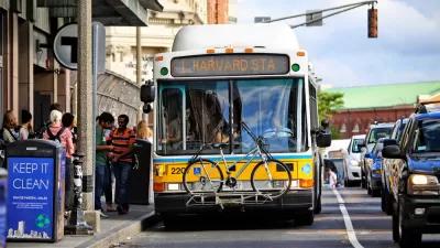
MBTA Announces Improved Bus Frequencies, Redesigned Route Map in Boston
A large system redesign is nearing implementation in and around Boston, but the new system map will require more drivers than the MBTA currently employs.
Latest 'Muni Forward' Changes Mean Route Changes, Frequency Improvements
Muni will soon launch the fourth phase of improvement to San Francisco's transit system.

Planetizen Federal Action Tracker
A weekly monitor of how Trump’s orders and actions are impacting planners and planning in America.

The Simple Legislative Tool Transforming Vacant Downtowns
In California, Michigan and Georgia, an easy win is bringing dollars — and delight — back to city centers.

San Francisco's School District Spent $105M To Build Affordable Housing for Teachers — And That's Just the Beginning
SFUSD joins a growing list of school districts using their land holdings to address housing affordability challenges faced by their own employees.

In More Metros Than You’d Think, Suburbs are Now More Expensive Than the City
If you're moving to the burbs to save on square footage, data shows you should think again.

The States Losing Rural Delivery Rooms at an Alarming Pace
In some states, as few as 9% of rural hospitals still deliver babies. As a result, rising pre-term births, no adequate pre-term care and "harrowing" close calls are a growing reality.

The Small South Asian Republic Going all in on EVs
Thanks to one simple policy change less than five years ago, 65% of new cars in this Himalayan country are now electric.
Urban Design for Planners 1: Software Tools
This six-course series explores essential urban design concepts using open source software and equips planners with the tools they need to participate fully in the urban design process.
Planning for Universal Design
Learn the tools for implementing Universal Design in planning regulations.
Smith Gee Studio
City of Charlotte
City of Camden Redevelopment Agency
City of Astoria
Transportation Research & Education Center (TREC) at Portland State University
US High Speed Rail Association
City of Camden Redevelopment Agency
Municipality of Princeton (NJ)