


Honolulu's one protected bike lane on King Street, while still a pilot project, has proven so successful that the city plans a major expansion to form a protected bike lane grid that will also tie-in with the new bike share and rail transit.
Honolulu's strategy to deal with "crippling car traffic" is to build more lanes—protected bicycle lanes, that is. More specifically, a "grid" of these lanes that have been shown to increase cycling by addressing the safety factor.
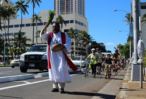
An opening ceremony for King Street's protected bike lane in December. Photo: Being 808 via PeopleForBikes.
Plans call for protected bike lanes to be built on South Street and on the "mauka-makai routes to be installed eventually on Ward Avenue, Keeaumoku, McCully, Pensacola and Piikoi streets," writes Marcel Honoré for the Honolulu Star-Advertiser. The plans were unveiled at a Tuesday meeting on the protected bike lane network.
The expansion ties in with two other transportation projects: the future bikeshare and the city's future elevated guideway, operational by 2019 according to plan if all goes well. Plans were unveiled at the meeting "to eventually install a protected bike lane on Halekauwila Street," underneath the guideway.
“These aren’t just bike projects, they’re policy statements” that include redesigning local streets so that they provide more options than just cars, city Department of Transportation Services Director Mike Formby said.
The new lanes will supplement "the King Street protected lane, also known as the cycle track, a pilot project installed on the mauka side of the street about nine months ago at a cost of about $500,000," writes Honoré. "The city removed 11 parking spaces on the outside of the lane to improve visibility, deputy director of transportation Mark Garrity told the (Tuesday meeting) crowd."
Hat tip to AASHTO's Daily Journal Update: Pedestrians/Bicycles section.
FULL STORY: City looks to more protected bike lanes to deal with traffic

Bike Lanes Help Sidewalks, Too
A growing body of evidence shows that bike lanes put more people on bikes while also helping those people on bikes stay off sidewalks. The latest example: Honolulu.
Cleveland to Boost Bike Safety With New Bike Lanes, School Programs
The program, using curriculum created by Cleveland Bikes, is part of a broader effort to improve safety along school routes.
Judge Halts Brooklyn Bike Lane Removal
Lawyers must prove the city was not acting “arbitrarily, capriciously, and illegally” in ordering the hasty removal.

Maui's Vacation Rental Debate Turns Ugly
Verbal attacks, misinformation campaigns and fistfights plague a high-stakes debate to convert thousands of vacation rentals into long-term housing.

Planetizen Federal Action Tracker
A weekly monitor of how Trump’s orders and actions are impacting planners and planning in America.

In Urban Planning, AI Prompting Could be the New Design Thinking
Creativity has long been key to great urban design. What if we see AI as our new creative partner?

Portland Raises Parking Fees to Pay for Street Maintenance
The city is struggling to bridge a massive budget gap at the Bureau of Transportation, which largely depleted its reserves during the Civd-19 pandemic.

Spokane Mayor Introduces Housing Reforms Package
Mayor Lisa Brown’s proposals include deferring or waiving some development fees to encourage more affordable housing development.

Houston Mayor Kills Another Bike Lane
The mayor rejected a proposed bike lane in the Montrose district in keeping with his pledge to maintain car lanes.
Urban Design for Planners 1: Software Tools
This six-course series explores essential urban design concepts using open source software and equips planners with the tools they need to participate fully in the urban design process.
Planning for Universal Design
Learn the tools for implementing Universal Design in planning regulations.
Gallatin County Department of Planning & Community Development
Heyer Gruel & Associates PA
JM Goldson LLC
City of Camden Redevelopment Agency
City of Astoria
Transportation Research & Education Center (TREC) at Portland State University
Jefferson Parish Government
Camden Redevelopment Agency
City of Claremont