


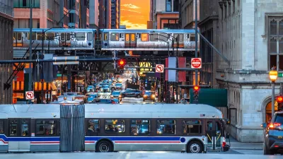
An analysis of infill transit stations built since 2012 along "L" routes in Chicago shows clear increases in ridership and transit oriented development.
"Over the past few years, Chicago has invested in three new 'infill' stations located along existing ‘L’ tracks, filling service gaps between stops and expanding access to the transit system," according to an article by Yonah Freemark and Mengwei Sun that credits those infill station with some of the increased ridership on the system as well as new opportunities for transit oriented development.
The CTA opened two infill stations in 2012, according to the article, "one at Morgan Street on the Green and Pink Lines and one at Oakton Street on the Yellow Line." Another station "opened at Cermak Road on the Green Line near the McCormick Place convention center in the South Loop neighborhood."
As Freemark and Sun note, "Morgan Station has been particularly effective in bringing new development to the West Loop and now attracts more than 2,300 daily riders as of March 2015." TheCermak-McCormick Place station, though brand new, has had an immediate impact on ridership. The article digs deeper into the initial data available for analysis in the wake of the new station's opening, on ridership on the "L" line, its effect on nearby bus lines, and its effect on the local real estate market.
FULL STORY: How the Cermak-McCormick ‘L’ station could create a real estate boom in the South Loop

Chicago Transit Agencies on Brink of Major Crisis
Without additional funding, regional transit agencies will be forced to cut services by 40 percent.
Study: Most Chicago Rideshare Trips Could Be Made by Transit
Researchers found that 99 percent of rideshare trips could be made by buses and trains — but the time savings roughly equal an hour’s wage.
Chicago Transit Increasing Rail Service to Pre-Pandemic Levels
The Chicago Transit Authority is close to returning both rail and bus service to pre-pandemic schedules, with some adjustments for new travel demand.

Planetizen Federal Action Tracker
A weekly monitor of how Trump’s orders and actions are impacting planners and planning in America.

San Francisco's School District Spent $105M To Build Affordable Housing for Teachers — And That's Just the Beginning
SFUSD joins a growing list of school districts using their land holdings to address housing affordability challenges faced by their own employees.

Can We Please Give Communities the Design They Deserve?
Often an afterthought, graphic design impacts everything from how we navigate a city to how we feel about it. One designer argues: the people deserve better.

The EV “Charging Divide” Plaguing Rural America
With “the deck stacked” against rural areas, will the great electric American road trip ever be a reality?

Judge Halts Brooklyn Bike Lane Removal
Lawyers must prove the city was not acting “arbitrarily, capriciously, and illegally” in ordering the hasty removal.

Engineers Gave America's Roads an Almost Failing Grade — Why Aren't We Fixing Them?
With over a trillion dollars spent on roads that are still falling apart, advocates propose a new “fix it first” framework.
Urban Design for Planners 1: Software Tools
This six-course series explores essential urban design concepts using open source software and equips planners with the tools they need to participate fully in the urban design process.
Planning for Universal Design
Learn the tools for implementing Universal Design in planning regulations.
Borough of Carlisle
Smith Gee Studio
City of Camden Redevelopment Agency
City of Astoria
Transportation Research & Education Center (TREC) at Portland State University
City of Camden Redevelopment Agency
Municipality of Princeton (NJ)