


Wonkblog illustrates the results of a "Natural Amenities Index" created by the federal government.

Christopher Ingraham shares insight into the Natural Amenities Index, created in the late 1990s by the U.S. Department of Agriculture to measure physical characteristics that enhance locations as a place to live.
According to Ingraham, "[t]he index combines 'six measures of climate, topography, and water area that reflect environmental qualities most people prefer.' Those qualities, according to the USDA, include mild, sunny winters, temperate summers, low humidity, topographic variation, and access to a body of water."
Ingraham took the data available in the index turned them into an interactive map, noting that California and Colorado do pretty well in the index, while "the lowest rankings clustered around the Minnesota/North Dakota border region."
FULL STORY: Every county in America, ranked by natural beauty


Interactive Map Reveals America's “Shade Deserts”
Launched by UCLA and American Forests to combat heat-related deaths, the tool maps the shade infrastructure for over 360 U.S. cities.

20 Safest and Most Dangerous US Cities for Pedestrians
Pedestrian safety is a vital component to a walkable city. Which large cities in the United States have a leg up, and which are trailing behind?
20 States Best and Least Prepared for Climate Change and Extreme Weather
A new study from CNBC ranks US states in order of sustainability and preparedness for climate change and extreme weather. A few might surprise you.

Planetizen Federal Action Tracker
A weekly monitor of how Trump’s orders and actions are impacting planners and planning in America.

San Francisco's School District Spent $105M To Build Affordable Housing for Teachers — And That's Just the Beginning
SFUSD joins a growing list of school districts using their land holdings to address housing affordability challenges faced by their own employees.

The Tiny, Adorable $7,000 Car Turning Japan Onto EVs
The single seat Mibot charges from a regular plug as quickly as an iPad, and is about half the price of an average EV.

Vehicle-related Deaths Drop 29% in Richmond, VA
The seventh year of the city's Vision Zero strategy also cut the number of people killed in alcohol-related crashes by half.

Seattle's Plan for Adopting Driverless Cars
Equity, safety, accessibility and affordability are front of mind as the city prepares for robotaxis and other autonomous vehicles.

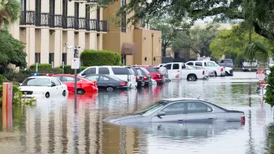
As Trump Phases Out FEMA, Is It Time to Flee the Floodplains?
With less federal funding available for disaster relief efforts, the need to relocate at-risk communities is more urgent than ever.
Urban Design for Planners 1: Software Tools
This six-course series explores essential urban design concepts using open source software and equips planners with the tools they need to participate fully in the urban design process.
Planning for Universal Design
Learn the tools for implementing Universal Design in planning regulations.
Smith Gee Studio
City of Charlotte
City of Camden Redevelopment Agency
City of Astoria
Transportation Research & Education Center (TREC) at Portland State University
US High Speed Rail Association
City of Camden Redevelopment Agency
Municipality of Princeton (NJ)