


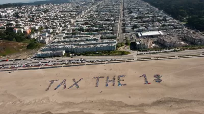
An analysis and accompanying interactive map from the Urban Institute show where the nation's richest and poorest tend to live. The map tells a tale of deeply ingrained wealth segregation.

Income and wealth inequality might not matter so much if rich and poor lived as neighbors. But for a long time in the United States they have not. "The patterns of where people live in most metropolitan areas — Washington is not unique — take the problems of inequality and make them even worse. They concentrate poverty and concentrate privilege at the same time."
City services and collective quality of life often align with the average prosperity of a neighborhood's residents. "And that means that people who can't afford an expensive home also don't get access to safe streets, cleaner air and better education."
In an analysis and a map depicting the entire country, "the Urban Institute's Rolf Pendall and Carl Hedman ranked Census tracts not just by their average household income. They constructed a single socioeconomic score that also captures the homeownership rate, the median home value and the share of people with college degrees."
While middling neighborhoods might fluctuate, the nation's richest and poorest communities have stayed quite stable: "deeply poor places tend to stay that way, but so do incredibly wealthy ones." The areas around Baltimore, Columbus, Dallas, Houston and Philadelphia exhibit especially stark geographic wealth divides.
FULL STORY: These maps show the vastly separate worlds of the rich and poor

How Falling Inequality Rates Mislead
While the vast majority of cities saw an increase—or no decrease—in neighborhood inequality since 1990, nearly 30 regions became more equal. But paper equality can be problematic when the rich simply up and left town.
What's Missed When Taking the Scenic Route?
An app that plots the most beautiful route across cities made news earlier this month, but one commenter worries about how taking the more scenic route could make it harder to improve quality of life in the "less-than-scenic" sections of cities.
Map Identifies DeKalb County Brownfield Sites
The GIS tool is designed to help developers find vacant and blighted lots that could be restored for new housing or other uses.

Planetizen Federal Action Tracker
A weekly monitor of how Trump’s orders and actions are impacting planners and planning in America.

Maui's Vacation Rental Debate Turns Ugly
Verbal attacks, misinformation campaigns and fistfights plague a high-stakes debate to convert thousands of vacation rentals into long-term housing.

San Francisco Suspends Traffic Calming Amidst Record Deaths
Citing “a challenging fiscal landscape,” the city will cease the program on the heels of 42 traffic deaths, including 24 pedestrians.

Amtrak Rolls Out New Orleans to Alabama “Mardi Gras” Train
The new service will operate morning and evening departures between Mobile and New Orleans.

The Subversive Car-Free Guide to Trump's Great American Road Trip
Car-free ways to access Chicagoland’s best tourist attractions.

San Antonio and Austin are Fusing Into one Massive Megaregion
The region spanning the two central Texas cities is growing fast, posing challenges for local infrastructure and water supplies.
Urban Design for Planners 1: Software Tools
This six-course series explores essential urban design concepts using open source software and equips planners with the tools they need to participate fully in the urban design process.
Planning for Universal Design
Learn the tools for implementing Universal Design in planning regulations.
Heyer Gruel & Associates PA
JM Goldson LLC
Custer County Colorado
City of Camden Redevelopment Agency
City of Astoria
Transportation Research & Education Center (TREC) at Portland State University
Jefferson Parish Government
Camden Redevelopment Agency
City of Claremont