


Looking for granular illustrations of the details of local economies? Look no further.
Emily Badger shares news of a new data mapping project that shows every job in the United States:
"[Economic differences] form economic identities that shape each city as much as their culture and geography do. And they're starkly — and beautifully — visible in a new visualization, made by Harvard Ph.D. student Robert Manduca, that maps nearly every job in America, one dot per job. His project, which draws on Census data reported by employers, is modeled off Dustin Cable's well-known racial dot map that mapped every person in the country."
The map uses red dots to represent manufacturing and trade; blue dots for professional services; green dots for healthcare, education, and government; and yellow dots for retail, hospitality, and other services.
Laura Bliss also picked up on the news of the new map, highlighting the benefits of dot maps and some of the job trends visible in maps of New York, San Jose, and San Francisco.
FULL STORY: Nearly every job in America, mapped in incredible detail


Friday Eye Candy: A Sorely-Needed Map of New York City Neighborhoods
Neighborhoods don't get the same official boundaries as cities, counties, states, and countries. So how do we know where one neighborhood ends and another begins?
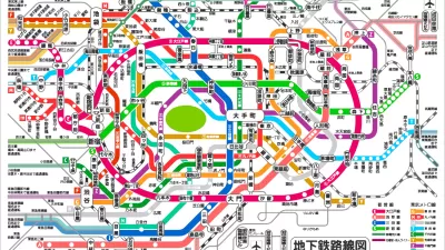
Friday Eye Candy: The World's Subway Systems, If You Could See Them From Above
Have you ever flown over a city and imagined all the subway lines running beneath the surface?
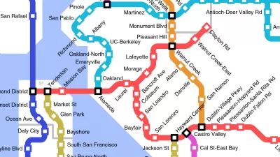
Friday Funny: Imagining Taco Bell-Oriented Rail Transit
A Reddit user created a transit map of the San Francisco Bay Area that connects Taco Bell locations, which, unlike rail public transit, have reached every corner of the region.

Planetizen Federal Action Tracker
A weekly monitor of how Trump’s orders and actions are impacting planners and planning in America.

San Francisco's School District Spent $105M To Build Affordable Housing for Teachers — And That's Just the Beginning
SFUSD joins a growing list of school districts using their land holdings to address housing affordability challenges faced by their own employees.

The Tiny, Adorable $7,000 Car Turning Japan Onto EVs
The single seat Mibot charges from a regular plug as quickly as an iPad, and is about half the price of an average EV.

Seattle's Plan for Adopting Driverless Cars
Equity, safety, accessibility and affordability are front of mind as the city prepares for robotaxis and other autonomous vehicles.

As Trump Phases Out FEMA, Is It Time to Flee the Floodplains?
With less federal funding available for disaster relief efforts, the need to relocate at-risk communities is more urgent than ever.

With Protected Lanes, 460% More People Commute by Bike
For those needing more ammo, more data proving what we already knew is here.
Urban Design for Planners 1: Software Tools
This six-course series explores essential urban design concepts using open source software and equips planners with the tools they need to participate fully in the urban design process.
Planning for Universal Design
Learn the tools for implementing Universal Design in planning regulations.
Smith Gee Studio
City of Charlotte
City of Camden Redevelopment Agency
City of Astoria
Transportation Research & Education Center (TREC) at Portland State University
US High Speed Rail Association
City of Camden Redevelopment Agency
Municipality of Princeton (NJ)