


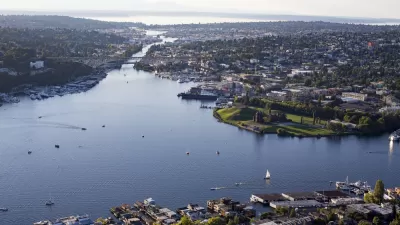
As increasing density and increasing housing costs raise temperatures all over Seattle, residents and planners are engaging in a comprehensive plan that will determine how the city grows over the next 20 years.
Ari Cetron provides insight into the comprehensive planning process underway at Seattle's Department of Planning and Development (DPD), examining in particular the plan's need to accommodate 120,000 projected new residents in the next 20 years.
The "essential question" posed by the Seattle 2035 plan, according to Cetron: "should we concentrate our growth into only a few areas or spread it around, with denser buildings across the city?" Currently DPD is considering four growth alternatives, with the aim of narrowing those four choices down to one option by July. Public comment on the current phase of planning ends June 18.
The four alternatives, according to the Seattle 2035 website:
- Continue Current Trends
- Guide growth to urban centers
- Guide growth to urban centers near light rail
- Guide growth to urban centers near transit
The website includes "highlights" for each of these alternatives.
Ceron's coverage is headlines with a promise to show five maps that will determine the city's future, and to deliver on that promise, Cetron chooses a map showing areas at risk for displacement along with four maps showing where each of the alternatives would locate the largest numbers of new housing.
FULL STORY: Seattle 2035: Five maps that will determine the city’s future

Environmental Criticism for the Seattle 2035 Comprehensive Plan
The Seattle 2035 will manage growth for one of the fastest growing cities in the country. But shouldn't it also mitigate the greenhouse gas emissions of this famously eco-conscious city?
Seattle Releases Draft Rezonings for its 'Urban Villages'
Seattle is planning to add height and density in "urban villages" around the city—part of the growth and affordability goals targeted by previous planning efforts by the city.
Seattle Ponders a New Approach to Zoning for its Comprehensive Plan Update
The city of Seattle will have an updated comprehensive plan by the end of 2024, with zoning changes to follow by 2025.

Planetizen Federal Action Tracker
A weekly monitor of how Trump’s orders and actions are impacting planners and planning in America.

San Francisco's School District Spent $105M To Build Affordable Housing for Teachers — And That's Just the Beginning
SFUSD joins a growing list of school districts using their land holdings to address housing affordability challenges faced by their own employees.

The Tiny, Adorable $7,000 Car Turning Japan Onto EVs
The single seat Mibot charges from a regular plug as quickly as an iPad, and is about half the price of an average EV.

Seattle's Plan for Adopting Driverless Cars
Equity, safety, accessibility and affordability are front of mind as the city prepares for robotaxis and other autonomous vehicles.

As Trump Phases Out FEMA, Is It Time to Flee the Floodplains?
With less federal funding available for disaster relief efforts, the need to relocate at-risk communities is more urgent than ever.

With Protected Lanes, 460% More People Commute by Bike
For those needing more ammo, more data proving what we already knew is here.
Urban Design for Planners 1: Software Tools
This six-course series explores essential urban design concepts using open source software and equips planners with the tools they need to participate fully in the urban design process.
Planning for Universal Design
Learn the tools for implementing Universal Design in planning regulations.
Smith Gee Studio
City of Charlotte
City of Camden Redevelopment Agency
City of Astoria
Transportation Research & Education Center (TREC) at Portland State University
US High Speed Rail Association
City of Camden Redevelopment Agency
Municipality of Princeton (NJ)