


Governing's recent study of gentrification systematically exaggerates gentrification in a variety of ways.

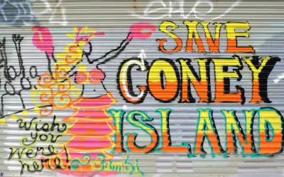
The ordinarily responsible Governing magazine is running a study of gentrification on its website; the study purports to show high levels of gentrification in some cities. For example, the study claims that 29 percent of New York's poor census tracts have gentrified.
But the methodology of this study is a bit suspect. It measures gentrification not by income or poverty, but by two criteria: (1) rising home values and (2) the growth of college graduates. The first method means that if people are growing poorer due to high housing costs, their neighborhood must be growing richer. It seems to me, however, that a neighborhood is not richer just because it is experiencing a housing bubble, or because it did not suffer a housing bust.
To be sure, there is some relationship between housing values and gentrification: other things being equal, higher incomes lead to higher demand lead to higher home prices. But other things are never equal: for example, in a small census tract with only a few houses, one or two condo buildings can skew average values upward.
The second element is also a less than ideal measure. In 1970, only 10 percent of Americans over 25 were college graduates—a percentage that nearly tripled over the following 40 years. Between 2000 and 2010, the percentage of college graduates increased in every single state. As college educations have become more common, I suspect that even the poorest places probably have more college graduates than they did a few decades ago. So if more college graduates=gentrification, one will naturally find gentrification everywhere. (To be fair, Governing used growth in college graduates rather than the raw number of graduates as a measure of gentrification; however, even less than explosive growth qualified census tracts as gentrifying. For example, one Kansas City census tract was classified as "gentrified" although its percentage of college graduates increased from 6 percent all the way up to 11 percent- a level only slightly higher than that of the city's poorest areas. The study described another neighborhood as "gentrified" because the percentage of graduates tripled- overlooking the fact that the percentage increased from 3 percent to a still-dismal 9 percent). Similarly, in Atlanta the dirt-poor Vine City neighborhood (where the median household income was under $20,000) was counted as "gentrified".
If gentrification means "more rich people" or "fewer poor people," it seems to me that a more appropriate measure of gentrification should address income: did incomes rise or fall? Did poverty rise or fall? And even if poverty fell, is a neighborhood's poverty rate anywhere close to suburban levels, or did an place with super-high poverty rates merely become a place with high poverty rates?
In addition, it seems to me that any study of gentrification should study degentrification as well: that is, to what extent were rising incomes in some urban neighborhoods balanced out by falling incomes and rising poverty in other neighborhoods? I suspect that a study considering this element would yield radically different results.*
*In particular the City Observatory website contains a wealth of data (pun intended) on neighborhood poverty.

Census Data: Black Americans Leaving Cities for Suburbs
The trend of Black Americans leaving urban areas for suburban communities mirrors the White Flight of the mid-20th century but for vastly different reasons and with vastly different consequences.
What We Really Mean When We Say Gentrification
The focus on gentrifying communities has, in many cases, eclipsed the similar problems facing more stagnant neighborhoods.

Columnist: New York City Needs Economic Recovery Strategies Other Than Gentrification
It's a tale of two cities as New York starts to emerge from the pandemic.

Planetizen Federal Action Tracker
A weekly monitor of how Trump’s orders and actions are impacting planners and planning in America.

Map: Where Senate Republicans Want to Sell Your Public Lands
For public land advocates, the Senate Republicans’ proposal to sell millions of acres of public land in the West is “the biggest fight of their careers.”

Restaurant Patios Were a Pandemic Win — Why Were They so Hard to Keep?
Social distancing requirements and changes in travel patterns prompted cities to pilot new uses for street and sidewalk space. Then it got complicated.

Platform Pilsner: Vancouver Transit Agency Releases... a Beer?
TransLink will receive a portion of every sale of the four-pack.

Toronto Weighs Cheaper Transit, Parking Hikes for Major Events
Special event rates would take effect during large festivals, sports games and concerts to ‘discourage driving, manage congestion and free up space for transit.”

Berlin to Consider Car-Free Zone Larger Than Manhattan
The area bound by the 22-mile Ringbahn would still allow 12 uses of a private automobile per year per person, and several other exemptions.
Urban Design for Planners 1: Software Tools
This six-course series explores essential urban design concepts using open source software and equips planners with the tools they need to participate fully in the urban design process.
Planning for Universal Design
Learn the tools for implementing Universal Design in planning regulations.
Heyer Gruel & Associates PA
JM Goldson LLC
Custer County Colorado
City of Camden Redevelopment Agency
City of Astoria
Transportation Research & Education Center (TREC) at Portland State University
Camden Redevelopment Agency
City of Claremont
Municipality of Princeton (NJ)