


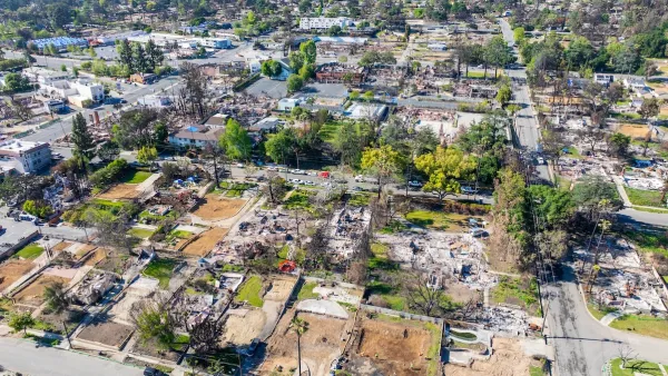
A new study by the union of Concerned Scientists faults local development policies that place homes in wildfire-prone areas for the increasing cost of wildfires. Should local agencies split the bill for the risks they've permitted?
"According to the Union of Concerned Scientists, across 13 Western states there are more than 1.2 million homes -- with a combined value of about $190 billion -- that are at high or very high risk of wildfires," reports Liam Moriarty.
The Department of Interior estimates that it will spend more than $1.8 billion fighting fires this year, but "Rachel Cleetus, an economist with the Union of Concerned Scientists, says that doesn’t even count the costs of other fire impacts." Additional costs, according to Cleetus, "include damage to property, pollution of watersheds, loss of livelihoods, impacts on public health and an increase in the risk of post-fire flooding."
The threat and cost of wildfires has been exacerbated by what Cleetus describes as a "misalignment of incentives."
"A lot of the firefighting money is coming from federal sources like the Department of the Interior and the Forest Service," says Cleetus in the article, "whereas a lot of decisions around development are being made at the local level through local zoning regulations, for example, where the folks who make those decisions are not paying for the firefighting cost."
FULL STORY: Study Says Poor Planning Contributes To Wildfire Costs

High-End Real Estate Makes Wildfires Worse
In Colorado and the West, the most desirable real estate is also the most likely to burn, writes Michael Kodas.
Tenant Advocates: Rent Gouging Rampant After LA Wildfires
The Rent Brigade says it's found evidence of thousands of likely instances of rent gouging. In some cases, the landlords accused of exploiting the fires had made campaign donations to those responsible for enforcement.

Wildlife Rebounds After the Eaton Fire
Following the devastation of the Eaton Fire, the return of wildlife and the regrowth of native plants are offering powerful signs of resilience and renewal.

Planetizen Federal Action Tracker
A weekly monitor of how Trump’s orders and actions are impacting planners and planning in America.

Map: Where Senate Republicans Want to Sell Your Public Lands
For public land advocates, the Senate Republicans’ proposal to sell millions of acres of public land in the West is “the biggest fight of their careers.”

Restaurant Patios Were a Pandemic Win — Why Were They so Hard to Keep?
Social distancing requirements and changes in travel patterns prompted cities to pilot new uses for street and sidewalk space. Then it got complicated.

Platform Pilsner: Vancouver Transit Agency Releases... a Beer?
TransLink will receive a portion of every sale of the four-pack.

Toronto Weighs Cheaper Transit, Parking Hikes for Major Events
Special event rates would take effect during large festivals, sports games and concerts to ‘discourage driving, manage congestion and free up space for transit.”

Berlin to Consider Car-Free Zone Larger Than Manhattan
The area bound by the 22-mile Ringbahn would still allow 12 uses of a private automobile per year per person, and several other exemptions.
Urban Design for Planners 1: Software Tools
This six-course series explores essential urban design concepts using open source software and equips planners with the tools they need to participate fully in the urban design process.
Planning for Universal Design
Learn the tools for implementing Universal Design in planning regulations.
Heyer Gruel & Associates PA
JM Goldson LLC
Custer County Colorado
City of Camden Redevelopment Agency
City of Astoria
Transportation Research & Education Center (TREC) at Portland State University
Camden Redevelopment Agency
City of Claremont
Municipality of Princeton (NJ)