


Based on empirical study, J. Alexander Maxwell and fellow University of Strathclyde researchers, in collaboration with Chuck Wolfe, argue for recalling historic patterns of pedestrian city settings in contemporary urban design and policies.
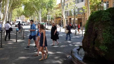
In a recent study, J. Alexander Maxwell and fellow researchers from the University of Strathclyde’s Urban Design Studies Unit in Glasgow found evidence that before the rise of the automobile, cities developed on a walkable “human” scale, with main streets that rarely exceeded 400 meters (a little more than 437 yards) (the "400-m rule"). Along with Chuck Wolfe, they argue that this uniformity reveals an underlying pattern to pedestrian city settings, which should be considered in contemporary urban design and policies.
They note:
Some elements of our urban environments change relatively quickly over time. New shops replace old shops, new buildings replace old buildings, and people come and go. However, other elements are more permanent and often reflect the planning policies, design paradigms, and technologies of the times when they were built. In a sense, these surviving features provide snapshots of our urban histories.
Among their preliminary explorations was a test of the 400-m rule against 100 historically diverse main street networks from cities in 30 different countries around the world. Figures illustrate historic cases, including main street networks from groupings of ancient, medieval, renaissance, baroque, and industrial study areas. Post-industrial cases included main street networks from groupings of Garden City, Radiant City, New Urbanism, and informal settlement patterns of development.
The results of this empirical study suggest that the observational claims behind the 400-m rule are in fact true.
The authors opine that the uniformity of the findings suggests an "effortless" expression of human tendencies – a signature that should be honored by policy and design consistent with this established norm.
Their conclusion illustrates typologies of liveable communities that attempt results that are very similar to the 400-m rule, and provides a call to action:
[M]ore conscious study is needed to tie together past and present. If underlying patterns of human-scale design in urban settings can be captured from historic environments and reapplied in contemporary policy and implementation contexts, then new purpose can be realized from past realities.
FULL STORY: City main street networks show a drastic shift away from historic patterns of human-scale design

Pedestrians First: Tools for a Walkable City
A comprehensive new website provides information on why and how to improve community walkability and offers practical tools for evaluating walking conditions.

Why College Campuses Make Ideal Models for Cities
College campuses serve as ideal models for cities, with their integrated infrastructure, vibrant communities, sustainability initiatives, and innovation hubs inspiring urban planning and development for a brighter future.
On the Importance of the Human Scale in Walkable Cities
Instead of density for density's sake (or for smart growth's sake), F. Kaid Benfield argues that the human scale is the key to walkable smart growth.

Trump Administration Could Effectively End Housing Voucher Program
Federal officials are eyeing major cuts to the Section 8 program that helps millions of low-income households pay rent.

Planetizen Federal Action Tracker
A weekly monitor of how Trump’s orders and actions are impacting planners and planning in America.

Ken Jennings Launches Transit Web Series
The Jeopardy champ wants you to ride public transit.

Driving Equity and Clean Air: California Invests in Greener School Transportation
California has awarded $500 million to fund 1,000 zero-emission school buses and chargers for educational agencies as part of its effort to reduce pollution, improve student health, and accelerate the transition to clean transportation.

Congress Moves to End Reconnecting Communities and Related Grants
The House Transportation and Infrastructure Committee moved to rescind funding for the Neighborhood Equity and Access program, which funds highway removals, freeway caps, transit projects, pedestrian infrastructure, and more.

From Throughway to Public Space: Taking Back the American Street
How the Covid-19 pandemic taught us new ways to reclaim city streets from cars.
Urban Design for Planners 1: Software Tools
This six-course series explores essential urban design concepts using open source software and equips planners with the tools they need to participate fully in the urban design process.
Planning for Universal Design
Learn the tools for implementing Universal Design in planning regulations.
Heyer Gruel & Associates PA
Ada County Highway District
Institute for Housing and Urban Development Studies (IHS)
City of Grandview
Harvard GSD Executive Education
Toledo-Lucas County Plan Commissions
Salt Lake City
NYU Wagner Graduate School of Public Service