


A comprehensive new website provides information on why and how to improve community walkability and offers practical tools for evaluating walking conditions.
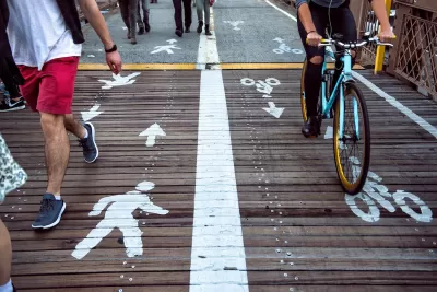
Walkability is a crucial first step in creating sustainable transportation in an urban environment.
Effectively understanding and measuring the complex ecology of walkability has proven challenging for many organizations and governments, given the various levels of policy-making and implementation involved. In the past, Western and Eurocentric standards have permeated measurement attempts and have included data collection practices that are too complicated to have utility in many parts of the world or at a level beyond that of the neighborhood.
To expand the measurement of walkability to more places and to promote a better understanding of walkability, the Institute for Transportation and Development Policy (ITDP) has developed the Pedestrians First online toolkit. This tool will facilitate the understanding and measurement of the features that promote walkability in urban environments around the world at multiple levels. With a better global understanding of walkability, and more consistent and frequent measurement of the walkability of urban environments, decision-makers will be empowered to enact policies that create more walkable urban areas.
FULL STORY: Pedestrians First: Tools for a Walkable City

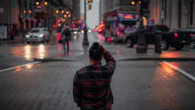
Study: Americans Spending Less Time Interacting in Public Space
American pedestrians are moving faster and spending less time connecting with other people when walking down city streets.

Denver to Shift Sidewalk Repair Work to City, Funded by Property Owners
The city is shifting from a piecemeal approach to sidewalk repairs that charged property owners with doing the work to a more streamlined, city-led process.
When ‘Prioritizing All Modes’ Is a Lie
In many cases, it’s impossible to prioritize the safety of pedestrians and other vulnerable road users without sacrificing some speed.

Planetizen Federal Action Tracker
A weekly monitor of how Trump’s orders and actions are impacting planners and planning in America.

Congressman Proposes Bill to Rename DC Metro “Trump Train”
The Make Autorail Great Again Act would withhold federal funding to the system until the Washington Metropolitan Area Transit Authority (WMATA), rebrands as the Washington Metropolitan Authority for Greater Access (WMAGA).

The Simple Legislative Tool Transforming Vacant Downtowns
In California, Michigan and Georgia, an easy win is bringing dollars — and delight — back to city centers.

The States Losing Rural Delivery Rooms at an Alarming Pace
In some states, as few as 9% of rural hospitals still deliver babies. As a result, rising pre-term births, no adequate pre-term care and harrowing close calls are a growing reality.

The Small South Asian Republic Going all in on EVs
Thanks to one simple policy change less than five years ago, 65% of new cars in this Himalayan country are now electric.

DC Backpedals on Bike Lane Protection, Swaps Barriers for Paint
Citing aesthetic concerns, the city is removing the concrete barriers and flexposts that once separated Arizona Avenue cyclists from motor vehicles.
Urban Design for Planners 1: Software Tools
This six-course series explores essential urban design concepts using open source software and equips planners with the tools they need to participate fully in the urban design process.
Planning for Universal Design
Learn the tools for implementing Universal Design in planning regulations.
Smith Gee Studio
City of Charlotte
City of Camden Redevelopment Agency
City of Astoria
Transportation Research & Education Center (TREC) at Portland State University
US High Speed Rail Association
City of Camden Redevelopment Agency
Municipality of Princeton (NJ)