


A new Complete Streets Design Manual is under consideration in Dallas City Hall, but according to a recent article explaining Dallas' move toward walkable neighborhoods, the city has some work to do before the idea fully takes hold.
David Flick explains some of the concepts behind walkable neighborhoods, as well as some of the cultural changes that will be necessary in selling the idea as Dallas city officials consider a new Complete Streets Design manual.
Some residents have already bought into the idea: “A telephone survey for the Complete Streets Design manual…found that 68 percent of residents believe being able to walk or bike to destinations would be good for the local economy,” writes Flick.
Flick also goes into some details about the features of the streetscape in the neighborhood of West Village, which is described as the city’s “most promising pedestrian neighborhood.” The article also includes an interactive map of neighborhoods throughout Dallas described in terms of walkability by local planners.
To those familiar with walkability and complete streets design, the article can be read as a first, early attempt at explaining some of these concepts in a major media publication. Do you think the article gets it right?
FULL STORY: Dallas following national trend toward walkable neighborhoods

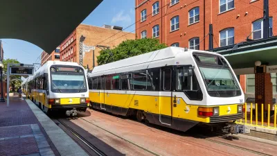
North Texas Transit Leaders Tout Benefits of TOD for Growing Region
At a summit focused on transit-oriented development, policymakers discussed how North Texas’ expanded light rail system can serve as a tool for economic growth.
North Texas Transportation Council Advocates for Road Safety, Rail Projects
The North Texas Regional Transportation Council issued a series of recommendations for state legislators that include more support for road safety projects and high-speed rail.

Dallas Considers Nixing Parking Requirements
According to one local official, Dallas projects routinely build 20 to 30 percent more parking than they need, driving up the cost of housing and leading to unsustainable land use patterns.

Planetizen Federal Action Tracker
A weekly monitor of how Trump’s orders and actions are impacting planners and planning in America.

Maui's Vacation Rental Debate Turns Ugly
Verbal attacks, misinformation campaigns and fistfights plague a high-stakes debate to convert thousands of vacation rentals into long-term housing.

San Francisco Suspends Traffic Calming Amidst Record Deaths
Citing “a challenging fiscal landscape,” the city will cease the program on the heels of 42 traffic deaths, including 24 pedestrians.

Amtrak Rolls Out New Orleans to Alabama “Mardi Gras” Train
The new service will operate morning and evening departures between Mobile and New Orleans.

The Subversive Car-Free Guide to Trump's Great American Road Trip
Car-free ways to access Chicagoland’s best tourist attractions.

San Antonio and Austin are Fusing Into one Massive Megaregion
The region spanning the two central Texas cities is growing fast, posing challenges for local infrastructure and water supplies.
Urban Design for Planners 1: Software Tools
This six-course series explores essential urban design concepts using open source software and equips planners with the tools they need to participate fully in the urban design process.
Planning for Universal Design
Learn the tools for implementing Universal Design in planning regulations.
Heyer Gruel & Associates PA
JM Goldson LLC
Custer County Colorado
City of Camden Redevelopment Agency
City of Astoria
Transportation Research & Education Center (TREC) at Portland State University
Jefferson Parish Government
Camden Redevelopment Agency
City of Claremont