


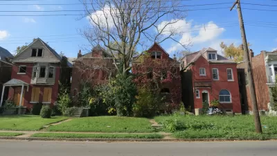
A HUD funded project has provided the city of St. Louis with a fine-grained map of residential real estate conditions across the city. Officials are hopeful the data will better guide the distribution of precious community development dollars.
An approach to neighborhood revitalization pioneered in Philadelphia has made its way to the banks of the Mississippi River, reports Tim Logan. "[St. Louis] on Tuesday unveiled a new 'market value analysis' of city real estate — a pile of housing statistics and maps — that it says will help better target public money, and draw private investment, to neighborhood redevelopment."
"It’s a shift from the old ward-based way of determining how to spend development dollars and move from just using experience, intuition and hunches to decide how to use the city’s limited resources, said Jeff Rainford, chief of staff to Mayor Francis Slay."
Backers don't see the analysis as a replacement for local knowledge, but as an objective supplement to help rationalize investments in community development.
"It’s designed to be the sort of fine-grained analysis that you can feel on a city street but that can get lost from 30,000 feet, said James Heard, director of HUD’s St. Louis field office," notes Logan. "And he hopes it’ll help the city get more bang out of limited federal bucks and make a more sophisticated case to draw private money to redevelopment projects."
FULL STORY: St. Louis turns to data to guide development

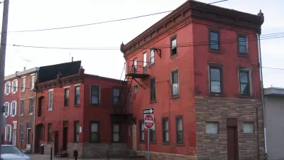
The Dark Side of the Rust Belt Revival
Cities in flyover country are facing new redevelopment challenges as companies relocate from costly coastal cities. In St. Louis, downtown revitalization has also brought plans to tackle blight, and the consequences for residents could be immense.
Real-Estate Site Locates Redevelopment Potential Across Philadelphia
A new map-based web tool created by a former city employee calculates the redevelopment potential of every parcel in Philadelphia.
St. Louis Finally Has a Developer for Long-Sought Redevelopment Project
The St. Louis City Council recently approved the initial steps for 1,800 acres of Maryland Heights floodplain. Plenty of hurdles remain, such as coming up with the money the developer wants to see the project through.

Planetizen Federal Action Tracker
A weekly monitor of how Trump’s orders and actions are impacting planners and planning in America.

Maui's Vacation Rental Debate Turns Ugly
Verbal attacks, misinformation campaigns and fistfights plague a high-stakes debate to convert thousands of vacation rentals into long-term housing.

Restaurant Patios Were a Pandemic Win — Why Were They so Hard to Keep?
Social distancing requirements and changes in travel patterns prompted cities to pilot new uses for street and sidewalk space. Then it got complicated.

Charlottesville Temporarily Has No Zoning Code
A judge ordered the Virginia city to throw out its newly revised zoning code, leaving permitting for new development in legal limbo.

In California Battle of Housing vs. Environment, Housing Just Won
A new state law significantly limits the power of CEQA, an environmental review law that served as a powerful tool for blocking new development.

Boulder Eliminates Parking Minimums Citywide
Officials estimate the cost of building a single underground parking space at up to $100,000.
Urban Design for Planners 1: Software Tools
This six-course series explores essential urban design concepts using open source software and equips planners with the tools they need to participate fully in the urban design process.
Planning for Universal Design
Learn the tools for implementing Universal Design in planning regulations.
Heyer Gruel & Associates PA
JM Goldson LLC
Custer County Colorado
City of Camden Redevelopment Agency
City of Astoria
Transportation Research & Education Center (TREC) at Portland State University
Jefferson Parish Government
Camden Redevelopment Agency
City of Claremont