


Despite better news all around for the quality of the air in America's urban environs, there is still much work to be done, especially for those making the American Lung Association's annual survey of the country's most polluted cities.
First the good news. "The American Lung Association's annual 'State of the Air' report -- based on EPA findings for 2009 through 2011 -- found that the three types of air pollution they track have all declined," reports Les Christie. The report's authors credit the Clean Air Act with helping to "prevent 160,000 deaths in 2010 (the last year data was available); avoid 1.7 million asthma attacks; and reduce hospital admissions and emergency room visits by 86,000 each."
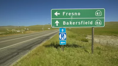
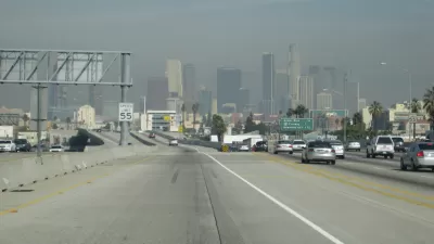
"Still," say the authors, "over 131.8 million people—42 percent of the nation—live where pollution levels are too often dangerous to breathe." And though "California has led the nation in implementing clean-air programs," polluted air remains a challenge throughout the state. "Four cities in the Golden State -- Bakersfield, Fresno, Hanford, and Los Angeles -- are in the top 10 in all three categories of pollution and have been for years," notes Christie. "Bakersfield had the worst air quality for any metro area for the third year in a row."
FULL STORY: America's air is getting cleaner - and less costly

California Has 8 of the 10 Most Polluted Cities in the U.S.
Despite ever-stricter air-quality regulations and dropping emissions, the American Lung Association once again finds the state to have some of the worst air in the nation.

Two New California Laws Take Aim at Pollution from Heavy-Duty Trucks
Trucks, which disproportionately contribute toward air pollution, will soon be subject to similar types of smog checks that apply to light-duty vehicles. A second bill signed by Gov. Gavin Newsom will spur movement toward cleaner alternatives.

'State of the Air Report' Finds More Cities With Worsening Pollution
The American Ling Association released its "State of the Air" report last week, finding that ozone and short-term particle pollution worsened in many cities in 2015-2017, compared to 2014-2016.

Planetizen Federal Action Tracker
A weekly monitor of how Trump’s orders and actions are impacting planners and planning in America.

Map: Where Senate Republicans Want to Sell Your Public Lands
For public land advocates, the Senate Republicans’ proposal to sell millions of acres of public land in the West is “the biggest fight of their careers.”

Restaurant Patios Were a Pandemic Win — Why Were They so Hard to Keep?
Social distancing requirements and changes in travel patterns prompted cities to pilot new uses for street and sidewalk space. Then it got complicated.

Platform Pilsner: Vancouver Transit Agency Releases... a Beer?
TransLink will receive a portion of every sale of the four-pack.

Toronto Weighs Cheaper Transit, Parking Hikes for Major Events
Special event rates would take effect during large festivals, sports games and concerts to ‘discourage driving, manage congestion and free up space for transit.”

Berlin to Consider Car-Free Zone Larger Than Manhattan
The area bound by the 22-mile Ringbahn would still allow 12 uses of a private automobile per year per person, and several other exemptions.
Urban Design for Planners 1: Software Tools
This six-course series explores essential urban design concepts using open source software and equips planners with the tools they need to participate fully in the urban design process.
Planning for Universal Design
Learn the tools for implementing Universal Design in planning regulations.
Heyer Gruel & Associates PA
JM Goldson LLC
Custer County Colorado
City of Camden Redevelopment Agency
City of Astoria
Transportation Research & Education Center (TREC) at Portland State University
Camden Redevelopment Agency
City of Claremont
Municipality of Princeton (NJ)