


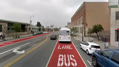
In a landmark ruling issued last week, the Delhi High Court upheld the use of New Delhi's streets for a 5.6-kilometer bus rapid transit corridor, in a blow to auto owners seeking have it removed for use by all traffic, including private vehicles.
Dario Hidalgo and Madhav Pai report on the court's ruling, which "advanced the idea that transportation facilities are for moving people,
not cars, and should favor all users, not just the minority fortunate
enough to use private cars."
The suit had been brought by Nyaya Bhoomi, who claimed "that the bus corridor was aimed at harassing
commuters and was a waste of public money. It said it resulted in
increased travel time for car users and longer idling time due to
traffic jams, resulting in wastage of fuel."
According to Hidalgo and Pai, the judges, Pradeep Nandrajog and Manmohan Singh, "reasoned that since a bus could transport up to 200 persons in the
course of one journey, as opposed to a car, which would transport 3 or 4
persons, it was not irrational to assign dedicated road space for
buses."
The judges also noted that the city's growing traffic congestion is a result of the increasing number of private vehicles on the road, and asserted that the only way to reduce congestion would be to improve public transportation.
FULL STORY: A Developed Country Is One in Which Rich People Use Public Transport

To Regain Transit Ridership, Policymakers Must Address Land Use and Housing
More buses and trains alone won't bring back riders; other incentives are needed to boost ridership and encourage new users.

Bus Rapid Transit Gaining in Popularity
As cities look to rebuild their transit systems, bus rapid transit provides a cheap and effective way to expand access and boost speed.
Controversial BRT Plans Revised in Los Angeles
The proposed changes to plans for a bus rapid transit route on Colorado Boulevard are an attempt to compromise between competing community concerns.

Planetizen Federal Action Tracker
A weekly monitor of how Trump’s orders and actions are impacting planners and planning in America.

Map: Where Senate Republicans Want to Sell Your Public Lands
For public land advocates, the Senate Republicans’ proposal to sell millions of acres of public land in the West is “the biggest fight of their careers.”

Restaurant Patios Were a Pandemic Win — Why Were They so Hard to Keep?
Social distancing requirements and changes in travel patterns prompted cities to pilot new uses for street and sidewalk space. Then it got complicated.

Platform Pilsner: Vancouver Transit Agency Releases... a Beer?
TransLink will receive a portion of every sale of the four-pack.

Toronto Weighs Cheaper Transit, Parking Hikes for Major Events
Special event rates would take effect during large festivals, sports games and concerts to ‘discourage driving, manage congestion and free up space for transit.”

Berlin to Consider Car-Free Zone Larger Than Manhattan
The area bound by the 22-mile Ringbahn would still allow 12 uses of a private automobile per year per person, and several other exemptions.
Urban Design for Planners 1: Software Tools
This six-course series explores essential urban design concepts using open source software and equips planners with the tools they need to participate fully in the urban design process.
Planning for Universal Design
Learn the tools for implementing Universal Design in planning regulations.
Heyer Gruel & Associates PA
JM Goldson LLC
Custer County Colorado
City of Camden Redevelopment Agency
City of Astoria
Transportation Research & Education Center (TREC) at Portland State University
Camden Redevelopment Agency
City of Claremont
Municipality of Princeton (NJ)