


Bill Lindeke discusses the history of Minneapolis' Skyways and argues why we shouldn't celebrate a system that he believes is failing its downtown.
August 26th marked the 50th anniversary of the Minneapolis Skyway System, and Lindeke gives readers a history lesson of the skyway design, going all the way back to the 1880's and the first elevated sidewalks and pedestrian bridges.
Lindeke traces Minneapolis's system to the genesis of the city's planning department in the late 1950s, and their vision for "preserviong the future of downtown." In a 1959 plan, "second-level walks" are introduced as a means to improve transportation and reduce congestion. According to Lindeke, "the 1959 plan is sanguine about skyways. Not only would they move faster, they'd lead healthier lives. As the plan states, 'persons in the central area will gain a more relaxed attitude which will presumably add to their efficiency and improve their general well-being and attitude toward life. Since there are so many of them, this could have a salutary effect on the whole city.' Second-level walks were the urban equivalent of Prozac."
These skyways have since become a staple design in the city, from the initial span crossing Marquette Avenue in 1962, through the 80's building boom and into present day. But Lindeke offers sharp criticism, begging the question of whether skyways are "one of the main things casting a dark shadow on a potential downtown renaissance."
Lindeke touts his belief that although the design was intended to improve the downtown core, it's actually hurting itself. "The density and diversity of a downtown sidewalk is pretty much what defines a city, and Minneapolis is missing out."
FULL STORY: Happy 50th Birthday to the Minneapolis Skyway System!

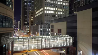
The Pandemic Has Not Been Kind to Pedestrian Skyways in the Twin Cities
Already a source of eternal controversy for their effects on street life and local business, pedestrian skyways have proven even more problematic during the pandemic.
A Dissenting Take on the Nicollet Mall Planning Process
While many are excited about the prospect of James Corner Field Operations redesigning the Nicollet Mall in Minneapolis, one commenter sees some of the worst dynamics of top-down planning at work.
New Designs Revealed for $50 Million Renovation of Minneapolis' Nicollet Mall
The public recently got a first look at a new design proposal from James Corner Field Operations for the $50 million improvement of Nicollet Mall in Minneapolis.

Planetizen Federal Action Tracker
A weekly monitor of how Trump’s orders and actions are impacting planners and planning in America.

Map: Where Senate Republicans Want to Sell Your Public Lands
For public land advocates, the Senate Republicans’ proposal to sell millions of acres of public land in the West is “the biggest fight of their careers.”

Restaurant Patios Were a Pandemic Win — Why Were They so Hard to Keep?
Social distancing requirements and changes in travel patterns prompted cities to pilot new uses for street and sidewalk space. Then it got complicated.

Platform Pilsner: Vancouver Transit Agency Releases... a Beer?
TransLink will receive a portion of every sale of the four-pack.

Toronto Weighs Cheaper Transit, Parking Hikes for Major Events
Special event rates would take effect during large festivals, sports games and concerts to ‘discourage driving, manage congestion and free up space for transit.”

Berlin to Consider Car-Free Zone Larger Than Manhattan
The area bound by the 22-mile Ringbahn would still allow 12 uses of a private automobile per year per person, and several other exemptions.
Urban Design for Planners 1: Software Tools
This six-course series explores essential urban design concepts using open source software and equips planners with the tools they need to participate fully in the urban design process.
Planning for Universal Design
Learn the tools for implementing Universal Design in planning regulations.
Heyer Gruel & Associates PA
JM Goldson LLC
Custer County Colorado
City of Camden Redevelopment Agency
City of Astoria
Transportation Research & Education Center (TREC) at Portland State University
Camden Redevelopment Agency
City of Claremont
Municipality of Princeton (NJ)