


From black flight to Asian invasion, Mark Wilson offers his take on a stunning map that lays out the changing demography of Los Angeles.
Eric Fischer earned widespread recognition in 2010 for assembling census data into demographic maps in "Race and Ethnicity (2000)", a project as artistic as it is cartographic. Now, with 2010 Census data in hand, Fischer zooms in to give us a closer look at how Los Angeles has changed in the last twenty years.
In particular, Wilson points to the explosion of the Asian population in Monterey Park, "the first mainland American city with an Asian majority." He also points to the exodus of blacks out of Compton, "a calling card for an entire movement of black hip-hop artists in the '90s," supplanted by an influx of Latinos.
"If there's one thing that's particularly depressing about this map," Wilson opines, "it's not really found in a story of which race ends up where, but in the fact that, over 20 years of so-called progress, these segregated pockets aren't melding. Rather, they're shifting in color."
FULL STORY: Infographic Shows The Shifting Racial Makeup of L.A. 20 Years After Rodney King

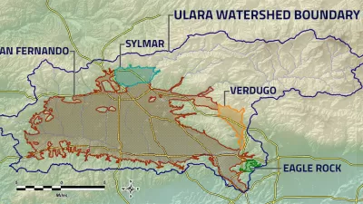
Superfund Project to Deliver Massive Water Supply Boon to Los Angeles
The semi-arid region of Los Angeles is often mistaken for a desert, but the local water supply is also constrained by the environmental sins of the 20th century. The water supply equation of Los Angeles will soon change, however.

Funding for Two Transit Projects Approved for the Valley in Los Angeles
Local funding for a new light rail line and upgrades to the G Line (née Orange Line) bus rapid transit route have been approved for the San Fernando Valley in Los Angeles.

L.A.'s San Fernando Valley $909 Million Closer to Light Rail
The last time rail transit crossed L.A.'s San Fernando Valley was in the early 1950s.

Planetizen Federal Action Tracker
A weekly monitor of how Trump’s orders and actions are impacting planners and planning in America.

Restaurant Patios Were a Pandemic Win — Why Were They so Hard to Keep?
Social distancing requirements and changes in travel patterns prompted cities to pilot new uses for street and sidewalk space. Then it got complicated.

Map: Where Senate Republicans Want to Sell Your Public Lands
For public land advocates, the Senate Republicans’ proposal to sell millions of acres of public land in the West is “the biggest fight of their careers.”

Maui's Vacation Rental Debate Turns Ugly
Verbal attacks, misinformation campaigns and fistfights plague a high-stakes debate to convert thousands of vacation rentals into long-term housing.

San Francisco Suspends Traffic Calming Amidst Record Deaths
Citing “a challenging fiscal landscape,” the city will cease the program on the heels of 42 traffic deaths, including 24 pedestrians.

California Homeless Arrests, Citations Spike After Ruling
An investigation reveals that anti-homeless actions increased up to 500% after Grants Pass v. Johnson — even in cities claiming no policy change.
Urban Design for Planners 1: Software Tools
This six-course series explores essential urban design concepts using open source software and equips planners with the tools they need to participate fully in the urban design process.
Planning for Universal Design
Learn the tools for implementing Universal Design in planning regulations.
Heyer Gruel & Associates PA
JM Goldson LLC
Custer County Colorado
City of Camden Redevelopment Agency
City of Astoria
Transportation Research & Education Center (TREC) at Portland State University
Camden Redevelopment Agency
City of Claremont
Municipality of Princeton (NJ)