


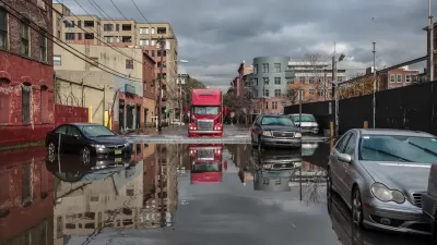
This article from Wired looks at new plans to prevent massive flooding in the low-lying Netherlands.
"More than half of the Netherlands sits below sea level, and if a megastorm were to break through these not-so-formidable dunes, the water could inundate Rotterdam and surrounding cities within 24 hours, flooding thousands of square miles, paralyzing the nation's economy, and devastating an area inhabited by more than 2 million people."
"Also on the drawing board are massive new storm-surge barriers and reinforcements around cities like Rotterdam and Dordrecht, built on the marshy delta where the Rhine and Meuse rivers meet the sea. "If you see a certain future, you must react," Stive says. And as he sees it, that future looks wet."
"Yet the chance of a breach at Ter Heijde is actually quite low, about 1 in 10,000 in any given year. (In the lingo of storm protection, that's known as a 10,000-year flood.) The coastline and river deltas of the Netherlands are arguably the best-protected lowlands in the world, and the Dutch are a little miffed at Al Gore for suggesting in An Inconvenient Truth that their homeland is as vulnerable to rising seas as far less protected places like Bangladesh and Florida."
"To Stive and other sea-rise hawks, however, 1 in 10,000 has become too risky. They want to crank up defenses in some critical areas to the level of 1 in 100,000."
FULL STORY: Before the Levees Break: A Plan to Save the Netherlands

FEMA Resilience Program Cuts Grant Funding
The Building Resilient Infrastructure and Communities program funded projects from flood prevention to power station upgrades.

Rising Above: Innovative Solutions for Waikīkī’s Sea-Level Challenges
The University of Hawaiʻi at Mānoa’s award-winning Waikīkī sea-level rise adaptation project combines science, architecture, and community input to create scalable solutions for climate resilience and coastal flood mitigation.

America’s Housing Crisis: Lessons Ignored and Challenges Ahead
A recent study reveals how decades of policy missteps, demographic shifts, and economic forces fueled America’s housing crisis, leaving millions — especially millennials — struggling amid rising demand, racial disparities, and climate-driven emergencies.

Planetizen Federal Action Tracker
A weekly monitor of how Trump’s orders and actions are impacting planners and planning in America.

Restaurant Patios Were a Pandemic Win — Why Were They so Hard to Keep?
Social distancing requirements and changes in travel patterns prompted cities to pilot new uses for street and sidewalk space. Then it got complicated.

Map: Where Senate Republicans Want to Sell Your Public Lands
For public land advocates, the Senate Republicans’ proposal to sell millions of acres of public land in the West is “the biggest fight of their careers.”

Maui's Vacation Rental Debate Turns Ugly
Verbal attacks, misinformation campaigns and fistfights plague a high-stakes debate to convert thousands of vacation rentals into long-term housing.

San Francisco Suspends Traffic Calming Amidst Record Deaths
Citing “a challenging fiscal landscape,” the city will cease the program on the heels of 42 traffic deaths, including 24 pedestrians.

California Homeless Arrests, Citations Spike After Ruling
An investigation reveals that anti-homeless actions increased up to 500% after Grants Pass v. Johnson — even in cities claiming no policy change.
Urban Design for Planners 1: Software Tools
This six-course series explores essential urban design concepts using open source software and equips planners with the tools they need to participate fully in the urban design process.
Planning for Universal Design
Learn the tools for implementing Universal Design in planning regulations.
Heyer Gruel & Associates PA
JM Goldson LLC
Custer County Colorado
City of Camden Redevelopment Agency
City of Astoria
Transportation Research & Education Center (TREC) at Portland State University
Camden Redevelopment Agency
City of Claremont
Municipality of Princeton (NJ)