


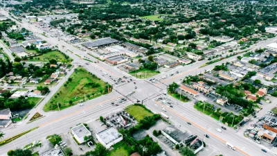
New census figures show that suburban growth is slowing down in the Sunbelt cities of California, Nevada and Arizona.
"The Census Bureau has released its annual estimate of county population changes, and as they have for years, the numbers for July 2006 to July 2007 show wild growth in Sunbelt cities in eastern California, Nevada and Arizona. But this year they also hint that the rate of growth may be slowing, and that coastal urban and suburban areas could be gaining ground. Riverside County, for instance, added 79,995 people in 2006 but just 66,365 last year -- not a reverse but perhaps a respite. San Diego's more modest growth, on the other hand, nearly quadrupled from 6,704 in 2006 to 26,497 in 2007."
"These numbers hardly suggest that sprawl is dead. It's best to view them as yet more evidence of the housing downturn. Demographer William Frey of the Brookings Institution spoke of a "migration correction." Just as bubble prices are declining -- in Los Angeles County, the median home price is down almost 13% from a year ago; County Assessor Rick Auerbach recently announced that his office had cut values on 41,000 properties by an average of $66,000 each -- boom-time mobility must decline too. As homes in urban areas lose market value, owners become loath to sell. They hunker down where they are, putting off buying that bigger, newer house on the fringes of the city or in more affordable markets such as Phoenix or Las Vegas."
FULL STORY: California sprawl slows down

Florida Law Would Change the Definition of ‘Sprawl’
One quick way to build sprawl.

Congestion Growing in Sunbelt Cities
Cities with rapidly growing populations and inadequate public transit systems are seeing more gridlock despite changes in commuting patterns and the rise of remote work.
The Pandemic Population Picture Comes Into Focus
Big U.S. cities lost population as the pandemic loitered into its second year. Suburban cities in Idaho, Arizona, Texas, and Florida grew the fastest during that time.

Planetizen Federal Action Tracker
A weekly monitor of how Trump’s orders and actions are impacting planners and planning in America.

Restaurant Patios Were a Pandemic Win — Why Were They so Hard to Keep?
Social distancing requirements and changes in travel patterns prompted cities to pilot new uses for street and sidewalk space. Then it got complicated.

Map: Where Senate Republicans Want to Sell Your Public Lands
For public land advocates, the Senate Republicans’ proposal to sell millions of acres of public land in the West is “the biggest fight of their careers.”

Maui's Vacation Rental Debate Turns Ugly
Verbal attacks, misinformation campaigns and fistfights plague a high-stakes debate to convert thousands of vacation rentals into long-term housing.

San Francisco Suspends Traffic Calming Amidst Record Deaths
Citing “a challenging fiscal landscape,” the city will cease the program on the heels of 42 traffic deaths, including 24 pedestrians.

California Homeless Arrests, Citations Spike After Ruling
An investigation reveals that anti-homeless actions increased up to 500% after Grants Pass v. Johnson — even in cities claiming no policy change.
Urban Design for Planners 1: Software Tools
This six-course series explores essential urban design concepts using open source software and equips planners with the tools they need to participate fully in the urban design process.
Planning for Universal Design
Learn the tools for implementing Universal Design in planning regulations.
Heyer Gruel & Associates PA
JM Goldson LLC
Custer County Colorado
City of Camden Redevelopment Agency
City of Astoria
Transportation Research & Education Center (TREC) at Portland State University
Camden Redevelopment Agency
City of Claremont
Municipality of Princeton (NJ)