


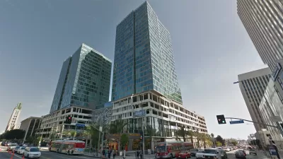
A swath of residential developments are ushering in a more dense and more lively atmosphere into L.A.'s Wilshire corridor. But many are concerned that the new residences will add too much traffic to an already congested area.
"There are more than two dozen residential developments -- adding up to thousands of new housing units -- either completed or proposed along the boulevard between downtown and the Miracle Mile district."
"Some of the projects are rehabs of shuttered office towers, such as the 1100 and 1010 Wilshire towers and the Mercury, the old Getty Oil headquarters across the street from Solair. Others are brand-new projects, sleek glass-and-steel towers like the Solair, where officials gathered Monday to mark the building's 'topping off'--the point in construction when the roof's concrete is poured and the structure itself fully enclosed."
"But the building boom is meeting with growing concerns from some residents. There is particular alarm over new projects planned near the corner of La Brea Avenue and Wilshire, already a major traffic bottleneck, where hundreds of new housing units have been proposed."
FULL STORY: Projects breathe life into Wilshire corridor

Op-Ed: Build a Dense Wilshire Corridor to Ease L.A.'s Housing Woes
Thom Mayne proposes a radical solution to Los Angeles' affordability/preservation problem: build up transit-friendly areas far beyond current densities, and leave the rest unchanged.
High Housing Costs Driving Down Transit Ridership in LA
When neighborhoods gentrify and displace lower-income residents, transit ridership suffers, new research shows.
How One L.A. Developer Uses the Law to Build Apartments
California’s density bonus law lets developers skirt some zoning regulations to build multifamily housing.

Planetizen Federal Action Tracker
A weekly monitor of how Trump’s orders and actions are impacting planners and planning in America.

Restaurant Patios Were a Pandemic Win — Why Were They so Hard to Keep?
Social distancing requirements and changes in travel patterns prompted cities to pilot new uses for street and sidewalk space. Then it got complicated.

Map: Where Senate Republicans Want to Sell Your Public Lands
For public land advocates, the Senate Republicans’ proposal to sell millions of acres of public land in the West is “the biggest fight of their careers.”

Orange County, Florida Adopts Largest US “Sprawl Repair” Code
The ‘Orange Code’ seeks to rectify decades of sprawl-inducing, car-oriented development.

Maui's Vacation Rental Debate Turns Ugly
Verbal attacks, misinformation campaigns and fistfights plague a high-stakes debate to convert thousands of vacation rentals into long-term housing.

San Francisco Suspends Traffic Calming Amidst Record Deaths
Citing “a challenging fiscal landscape,” the city will cease the program on the heels of 42 traffic deaths, including 24 pedestrians.
Urban Design for Planners 1: Software Tools
This six-course series explores essential urban design concepts using open source software and equips planners with the tools they need to participate fully in the urban design process.
Planning for Universal Design
Learn the tools for implementing Universal Design in planning regulations.
Heyer Gruel & Associates PA
JM Goldson LLC
Custer County Colorado
City of Camden Redevelopment Agency
City of Astoria
Transportation Research & Education Center (TREC) at Portland State University
Camden Redevelopment Agency
City of Claremont
Municipality of Princeton (NJ)