


The second edition of this seminal historical planning study of Washington, D.C. offers readers an in-depth look at the city's birth and creation.
 Gutheim and Lee's second edition of Worthy of the Nation updates Gutheim's first edition, published in 1977 as one of three National Capital Planning Commission (NCPC) historical studies, the other two being The Federal City: Plans and Realities and Planning Washington, 1924-1976: An Era of Planning for the National Capital and Environs. Planning Washington was a pamphlet history of the commission; The Federal City was an exhibit catalog. Gutheim wanted Worthy to be seen as an accompaniment to his 1949 work, The Potomac.
The second edition of Worthy of the Nation republishes most of the original text. In the first edition, Gutheim wrote a narrative history of planning in Washington up to 1926, the "Year of Decision," or the year that the predecessor to the National Capital Planning Commission was created. Following that, the text covered the early history of the commission and a variety of themes (transportation, comprehensive planning, redevelopment, and metropolitanism). In the new edition, Lee has rewritten the prologue on the L'Enfant plan, and the photographic essays have been deleted. The thematic chapters that followed the chapter on the creation of NCPC have been re-organized into a more chronological flow, and two chapters added to bring readers to present day. The text is supplemented and bolstered by substantial bibliographic notes and essays at the end. Peter Penczer has redone virtually all of the photographic presentations throughout, and contributed 30 photographs to the new chapters.
Surprisingly, very few complete histories of planning in Washington have been published even though the nation's capital is renowned as America's greatest planned city. In 1932, the Washington Society of Engineers published Planning and Building the City of Washington in commemoration of the George Washington Bicentennial, but its real emphasis (unsurprising for engineers) was the building, not the planning. Similarly, the Corps of Engineers published A City for the Nation: the Army Engineers and the Building of Washington, D.C., 1790-1967 with an emphasis on implementation of plans by the Corps. More recently, Alan Lessoff covered a critical period of Washington's development (The Nation and Its City: Politics, Corruption, and Progress in Washington, D.C., 1861-1902), and Richard Longstreth covered the development of the National Mall (The Mall in Washington, 1791-1991). For the longest time, Worthy of the Nation has stood alone as the sole monograph to cover the planning of Washington.
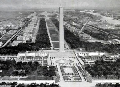
Planning in Washingtonhas gone through many permutations, beginning with the plan devised by L'Enfant and revised by Andrew Ellicott. That plan has remained the plan for downtown Washington, though revised somewhat by the McMillan Commission-the third great plan for Washington. [The second plan was "the permanent system of highways" that outlined the future development of "suburban" Washington-that area outside the L'Enfant plan.]
A number of commissions and other bodies are or have been responsible for various aspects of Washington planning, the National Capital Planning Commission being only one. As the guardian of the legacy of the McMillan Plan, the Commission of Fine Arts (CFA) has had a substantial role in city planning in the District since 1910. The body that became the National Capital Planning Commission was created in 1924 with responsibility for parks and two years later given comprehensive planning responsibility (it was reorganized in 1952). The planning commission had this role until 1973. Other important bodies include the Zoning Commission, the Pennsylvania Avenue Development Corporation (PADC) in the 1970s and 1980s, the Redevelopment Land Agency (RLA), and the National Capital Housing Authority (NCHA).
Where the new edition falls down is the new text covering the complexities of the past 30 years. Admittedly, it is a tricky task. Although Worthy is not strictly an official history of the National Capital Planning Commission, the commission is the sponsor. The past 30 years have seen a great diminution of the commission's authority: Home rule transferred responsibility for municipal planning to the District of Columbia, leaving responsibility for protecting the federal interest (broadly defined for both DC and the region) to the commission.
Worthy does not clearly deal with this change in the commission's role in the District of Columbia. The ambiguity of this work not being an official history of the commission, yet being published by the commission, causes the updated section to be unbalanced. The text leaves out much of the nitty-gritty of planning and instead narrates development and those parts of planning left to the commission (the monumental core of the city, basically) in broad brush strokes. As the economy fluctuated in the 1970s, 1980s, and 1990s, development did, of course, happen-often in the absence of, or contrary to, plans. The fortunes of the District's Office of Planning rose, fell, and have risen again.
One comprehensive plan was produced by the District in 1984 (and another is nearly through the process as of this writing-23 years later). Yet, the story of the activities and initiatives of the District's Office of Planning is barely touched upon except for its high points (and the wealth of its documents and plans not evidently consulted). The continuing roles and activities of the other planning bodies are not treated at all.
The two plans produced in the 1990s by NCPC, the Extending the Legacy plan and the Memorials and Monuments Master Plan are extensively covered (and illustrated) and overemphasized, consuming 8 pages (out of the total 55 in the new chapters). These plans by the commission attempted to cope with the perceived overcrowding of the National Mall with memorials and museums and were presented as the next McMillan plan. The significance, effect, and fate of these plans remain quite uncertain. The fragmentation of planning activities overall in the city over the last 30 years is not fully acknowledged, nor are the complex interrelationships and dependencies among them explored or explained. Regrettably, too, interesting points of discussion are hidden in the bibliographic essays at the end of the book.
In his prologue to the first edition of Worthy of the Nation, Gutheim states that "Washington is expected to exemplify effective urban planning. As the literature of urban history unfolds, there will be some larger appreciation of the city's accomplishments, and greater attention to precisely what did emerge from the continuous and comprehensive planning efforts." "How the city developed over two centuries to secure its place on the world stage is the subject of this book," according to the prologue of the new edition. This shift in emphasis from planning to development indicates the author's approach, at least to the final 30 years covered. Ironically, in his preface to the first edition, Gutheim, having finished writing the book, expressed regret that he could not do it all over again. That might have been a wise point from which to start this new edition.
Worthy of the Nation: Washington, D.C. from L'Enfant to the National Capital Planning Commission (Second edition). By Frederick Gutheim and Antoinette J. Lee. Baltimore, MD: Johns Hopkins University Press, 2006; 430 pp., illustrations, tables, appendices, index; cloth $65.00.
Matthew B. Gilmore is a consultant, editor, author, and teacher in Washington, D.C. He is the founder and editor of H-DC: Washington, D.C. History Network; member of the editorial board of Washington History and sometime co-guest editor. Since 2005 he has been Vice President for Networks at H-Net. He recently co-authored Historic Photos of Washington, D.C. His consulting work has been in geographic information systems (GIS) and government performance management.


Planetizen Federal Action Tracker
A weekly monitor of how Trump’s orders and actions are impacting planners and planning in America.

Map: Where Senate Republicans Want to Sell Your Public Lands
For public land advocates, the Senate Republicans’ proposal to sell millions of acres of public land in the West is “the biggest fight of their careers.”

Restaurant Patios Were a Pandemic Win — Why Were They so Hard to Keep?
Social distancing requirements and changes in travel patterns prompted cities to pilot new uses for street and sidewalk space. Then it got complicated.

Platform Pilsner: Vancouver Transit Agency Releases... a Beer?
TransLink will receive a portion of every sale of the four-pack.

Toronto Weighs Cheaper Transit, Parking Hikes for Major Events
Special event rates would take effect during large festivals, sports games and concerts to ‘discourage driving, manage congestion and free up space for transit.”

Berlin to Consider Car-Free Zone Larger Than Manhattan
The area bound by the 22-mile Ringbahn would still allow 12 uses of a private automobile per year per person, and several other exemptions.
Urban Design for Planners 1: Software Tools
This six-course series explores essential urban design concepts using open source software and equips planners with the tools they need to participate fully in the urban design process.
Planning for Universal Design
Learn the tools for implementing Universal Design in planning regulations.
Heyer Gruel & Associates PA
JM Goldson LLC
Custer County Colorado
City of Camden Redevelopment Agency
City of Astoria
Transportation Research & Education Center (TREC) at Portland State University
Camden Redevelopment Agency
City of Claremont
Municipality of Princeton (NJ)