


The online tool can help city and state officials understand where zoning codes need reform and how they compare to other localities.

The National Zoning Atlas, a project that seeks to help citizens and policymakers understand the zoning landscape in their areas, is expanding its reach rapidly, reports Elizabeth Daigneau in Route Fifty.
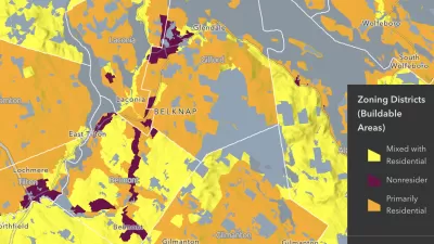
“Last week, the project announced the launch of the Arizona Zoning Atlas. Roughly 36 states have been mapped, some in their entirety and others just in certain metro areas or jurisdictions.” Data is almost complete for New Mexico and Nevada, with metro areas in the works in Colorado, New York, and North Carolina.
The project lets viewers compare zoning codes and access data about lot sizes, parking requirements, and other regulations. Vermont, the state with the largest average lot size at 1.8 acres, used the atlas maps to highlight the need for reduced lot sizes. “State officials used the Vermont Zoning Atlas to show residents how most Vermont towns disappear from the map when a user selects for areas where single-family homes are allowed on lots less than one-quarter acre.”
FULL STORY: See how your state uses zoning codes to control land use

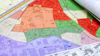
How a National Zoning Atlas Can Clarify a Legal Patchwork
A massive effort is underway to compile local zoning regulations and other laws that impact how and where housing is built.
National Zoning Atlas Makes Headway
The project aims to bring zoning data from around the country into one database, making it easier for planners and researchers to compare policies and their impacts.

Texas Legislature’s Surprising Pro-Housing Swing
Smaller homes on smaller lots, office to apartment conversions, and 40% less say for NIMBYs, vote state lawmakers.

Planetizen Federal Action Tracker
A weekly monitor of how Trump’s orders and actions are impacting planners and planning in America.

Restaurant Patios Were a Pandemic Win — Why Were They so Hard to Keep?
Social distancing requirements and changes in travel patterns prompted cities to pilot new uses for street and sidewalk space. Then it got complicated.

Map: Where Senate Republicans Want to Sell Your Public Lands
For public land advocates, the Senate Republicans’ proposal to sell millions of acres of public land in the West is “the biggest fight of their careers.”

Maui's Vacation Rental Debate Turns Ugly
Verbal attacks, misinformation campaigns and fistfights plague a high-stakes debate to convert thousands of vacation rentals into long-term housing.

San Francisco Suspends Traffic Calming Amidst Record Deaths
Citing “a challenging fiscal landscape,” the city will cease the program on the heels of 42 traffic deaths, including 24 pedestrians.

California Homeless Arrests, Citations Spike After Ruling
An investigation reveals that anti-homeless actions increased up to 500% after Grants Pass v. Johnson — even in cities claiming no policy change.
Urban Design for Planners 1: Software Tools
This six-course series explores essential urban design concepts using open source software and equips planners with the tools they need to participate fully in the urban design process.
Planning for Universal Design
Learn the tools for implementing Universal Design in planning regulations.
Heyer Gruel & Associates PA
JM Goldson LLC
Custer County Colorado
City of Camden Redevelopment Agency
City of Astoria
Transportation Research & Education Center (TREC) at Portland State University
Camden Redevelopment Agency
City of Claremont
Municipality of Princeton (NJ)