


The project aims to bring zoning data from around the country into one database, making it easier for planners and researchers to compare policies and their impacts.
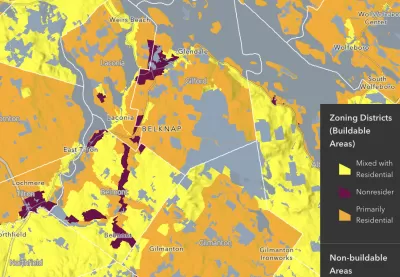
An article in PD&R Edge highlights progress on the National Zoning Atlas, an effort to consolidate nationwide zoning data into one GIS database to let researchers analyze and compare zoning policies and their effects. “The purpose of the atlas is to offer insight into zoning’s effects and democratize land use decisionmaking through comprehensive, digitized, and user-friendly zoning information.”
The creators of the Zoning Atlas say “the decentralization of zoning laws has hindered the identification of problems arising from land use regulations.” The effort is already underway in 21 states, and almost complete in New Hampshire.
“An ongoing challenge that the atlas can help address is the obfuscating effects of complex and competing land use interests to reform.” As the article explains, “Aggregating this information makes the scale of statewide challenges more readily apparent and could bring stakeholders on board to address the collective action problems that intricate zoning systems pose.”
FULL STORY: Creating the National Zoning Atlas


National Zoning Atlas Expands
The online tool can help city and state officials understand where zoning codes need reform and how they compare to other localities.
How a National Zoning Atlas Can Clarify a Legal Patchwork
A massive effort is underway to compile local zoning regulations and other laws that impact how and where housing is built.

Texas Legislature’s Surprising Pro-Housing Swing
Smaller homes on smaller lots, office to apartment conversions, and 40% less say for NIMBYs, vote state lawmakers.

Planetizen Federal Action Tracker
A weekly monitor of how Trump’s orders and actions are impacting planners and planning in America.

Maui's Vacation Rental Debate Turns Ugly
Verbal attacks, misinformation campaigns and fistfights plague a high-stakes debate to convert thousands of vacation rentals into long-term housing.

San Francisco Suspends Traffic Calming Amidst Record Deaths
Citing “a challenging fiscal landscape,” the city will cease the program on the heels of 42 traffic deaths, including 24 pedestrians.

Amtrak Rolls Out New Orleans to Alabama “Mardi Gras” Train
The new service will operate morning and evening departures between Mobile and New Orleans.

The Subversive Car-Free Guide to Trump's Great American Road Trip
Car-free ways to access Chicagoland’s best tourist attractions.

San Antonio and Austin are Fusing Into one Massive Megaregion
The region spanning the two central Texas cities is growing fast, posing challenges for local infrastructure and water supplies.
Urban Design for Planners 1: Software Tools
This six-course series explores essential urban design concepts using open source software and equips planners with the tools they need to participate fully in the urban design process.
Planning for Universal Design
Learn the tools for implementing Universal Design in planning regulations.
Heyer Gruel & Associates PA
JM Goldson LLC
Custer County Colorado
City of Camden Redevelopment Agency
City of Astoria
Transportation Research & Education Center (TREC) at Portland State University
Jefferson Parish Government
Camden Redevelopment Agency
City of Claremont