


A nationwide ‘digital zoning atlas’ shows how different zoning districts overlap with and affect transportation, infrastructure, and housing affordability.
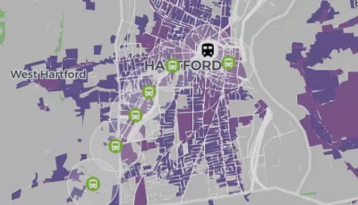
Inspired by a Connecticut project led by Cornell professor Sara Bronin, a group of academics, advocates, and policymakers are creating a nationwide ‘zoning atlas’ that will visualize local zoning codes and highlight how zoning rules impact the housing market. As Carl Smith reports in Governing, “Connecticut has the only statewide atlas that has been completed to date, but projects are already underway in California, Hawaii, Massachusetts, Montana, New Hampshire, New York and Ohio.”
The Connecticut project led to concrete policy changes, according to DesegregateCT director Peter Harrison. “You click and change from single-family housing allowed as-of-right to multifamily as-of-right, and the map goes blank — the story we’re trying to tell becomes real at a scale and speed that we could not do without it.”
The national effort is bringing together researchers from other states to map similar data. “This will help researchers who want to understand zoning’s impact on housing, education, environmental quality, climate change, transportation patterns, the economy and even government finances.”
Bronin and her collaborators hope that the atlas will provide a data-driven tool to help policymakers make informed decisions. “Our hope is that we’re laying the groundwork for many different people to use this information to guide decisions and also to engage people in the process of planning.”
FULL STORY: Digital Atlas Reveals Zoning’s Impact on Affordable Housing


NYC Council Approves Brooklyn Rezoning Plan
The Atlantic Avenue Mixed Use Plan includes infrastructure investments and could bring 4,600 new housing units to parts of Brooklyn.

DC Residents Want Affordability Over ‘Character’
A poll finds that most residents want to see changes in zoning and land use laws that unlock more housing construction in the District and improve affordability.

NYC’s Proposed Zoning Reforms Lag Behind Other Cities
Cities like Austin and Minneapolis are making major changes to their zoning codes to encourage housing construction, but New York’s proposed reforms are far less ambitious.

Planetizen Federal Action Tracker
A weekly monitor of how Trump’s orders and actions are impacting planners and planning in America.

Maui's Vacation Rental Debate Turns Ugly
Verbal attacks, misinformation campaigns and fistfights plague a high-stakes debate to convert thousands of vacation rentals into long-term housing.

San Francisco Suspends Traffic Calming Amidst Record Deaths
Citing “a challenging fiscal landscape,” the city will cease the program on the heels of 42 traffic deaths, including 24 pedestrians.

Defunct Pittsburgh Power Plant to Become Residential Tower
A decommissioned steam heat plant will be redeveloped into almost 100 affordable housing units.

Trump Prompts Restructuring of Transportation Research Board in “Unprecedented Overreach”
The TRB has eliminated more than half of its committees including those focused on climate, equity, and cities.

Amtrak Rolls Out New Orleans to Alabama “Mardi Gras” Train
The new service will operate morning and evening departures between Mobile and New Orleans.
Urban Design for Planners 1: Software Tools
This six-course series explores essential urban design concepts using open source software and equips planners with the tools they need to participate fully in the urban design process.
Planning for Universal Design
Learn the tools for implementing Universal Design in planning regulations.
Heyer Gruel & Associates PA
JM Goldson LLC
Custer County Colorado
City of Camden Redevelopment Agency
City of Astoria
Transportation Research & Education Center (TREC) at Portland State University
Jefferson Parish Government
Camden Redevelopment Agency
City of Claremont