


A seven-block stretch of Main Street will be permanently blocked off to traffic and enhanced to create a vibrant, pedestrian friendly zone.
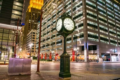
“Houston is finally tackling its walkability issue head-on” by transforming a seven-block portion of downtown’s Main Street into a car-free corridor, according to an article in Chron. Renee Yan reports the project, called “More Space: Mainstreet 2.0,” is in its final design and engineering phase and will likely break ground next year. In addition to lighting, stormwater, and aesthetic improvements, the street will be raised so it is level with the sidewalk. Work is expected to be completed in time for Houston to host the 2026 FIFA World Cup matches.
The project was inspired by an initiative the city undertook in 2021 to support local businesses during the pandemic. Chron previously reported that “[t]he city launched it as a pilot program to restrict car traffic and allow restaurants and bars to create gathering spaces along Main Street.” The program was very popular with residents and business owners, so after it expired in 2023, the city council voted unanimously to make it permanent.
Houston isn’t the only city to make pandemic-era car-free street projects permanent after positive reaction from the public and boosts to local restaurants. Other places in the U.S. that have done so include San Francisco’s John F. Kennedy Drive; 34th Avenue in Jackson Heights, Queens; multiple streets in Manhattan’s Meatpacking District in New York City; California Ave in Palo Alto.
FULL STORY: Project aims to make Downtown Houston zone more walkable by 2026


Retro-silient?: America’s First “Eco-burb,” The Woodlands Turns 50
A master-planned community north of Houston offers lessons on green infrastructure and resilient design, but falls short of its founder’s lofty affordability and walkability goals.

Houston Developers Question Mayor’s Stance on Pedestrian Projects
The new mayor’s reversal of road safety projects, some already underway or completed, is raising eyebrows among developers who say residents want walkable, mixed-use streets.
Houston Supportive Housing Development Sparks Debate
Critics say a proposed apartment building would negatively impact the neighborhood’s walkability.

Rethinking Redlining
For decades we have blamed 100-year-old maps for the patterns of spatial racial inequity that persist in American cities today. An esteemed researcher says: we’ve got it all wrong.

Planetizen Federal Action Tracker
A weekly monitor of how Trump’s orders and actions are impacting planners and planning in America.

Walmart Announces Nationwide EV Charging Network
The company plans to install electric car chargers at most of its stores by 2030.

Seattle’s Pike Place Market Leans Into Pedestrian Infrastructure
After decades of debate, the market is testing a car ban in one of its busiest areas and adding walking links to the surrounding neighborhood.

The World’s Longest Light Rail Line is in… Los Angeles?
In a city not known for its public transit, the 48.5-mile A Line is the longest of its kind on the planet.

Quantifying Social Infrastructure
New developments have clear rules for ensuring surrounding roads, water, and sewers can handle new users. Why not do the same for community amenities?
Urban Design for Planners 1: Software Tools
This six-course series explores essential urban design concepts using open source software and equips planners with the tools they need to participate fully in the urban design process.
Planning for Universal Design
Learn the tools for implementing Universal Design in planning regulations.
City of Moorpark
City of Tustin
City of Camden Redevelopment Agency
City of Astoria
Transportation Research & Education Center (TREC) at Portland State University
Regional Transportation Commission of Southern Nevada
Toledo-Lucas County Plan Commissions