


Housing that uses federal funding will be subject to stricter regulations that reflect increasing flood risks.
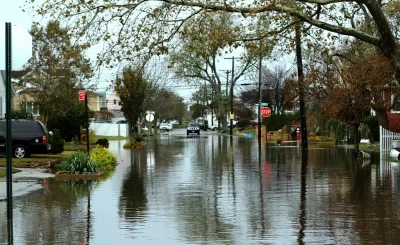
The U.S. Department of Housing and Urban Development issued new flood protection requirements for housing that uses federal funds, finalizing the rule last week, according to an article by Ysabelle Kempe in Smart Cities Dive. “The new rule revises HUD’s regulations to implement the Federal Flood Risk Management Standard, a strengthened flood risk-reduction standard established in 2015 following the devastating impacts of Hurricane Sandy. Rather than using the 100-year floodplain, the agency will now base elevation and floodproofing requirements on the floodplains determined by this forward-looking standard.”
The rule comes as more communities face heightened flooding and displacement risk. “Despite real estate industry concerns that the rule will spike construction costs, HUD says it will save U.S. communities millions of dollars by reducing flood insurance premiums, building damage, relocation costs and loss of income during floods.” According to HUD, “while the rule could increase upfront construction costs, the costs of elevating new construction are marginal compared with the total construction price tag.”
The rule also updates regulations for multifamily housing insured by HUD, now requiring the lowest floor of projects to be at least two feet above the 100-year floodplain.
FULL STORY: HUD tightens flood-protection rules for new and rebuilt homes

800 New Homes Approved for Houston's Floodplain
The city of Houston approved a new development that doesn't meet new elevations standards approved by the city of Houston earlier this month.
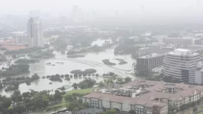
Houston Seriously Tightens Rules on Floodplain Construction
It was the city's "first major regulatory response" to Hurricane Harvey.

How Cities Can Support Climate Adaptation
In the face of federal cuts to climate resilience funding, a panel at ULI’s Resilience Summit offered suggestions for maintaining managed retreat and other climate adaptation programs.

Planetizen Federal Action Tracker
A weekly monitor of how Trump’s orders and actions are impacting planners and planning in America.

Congressman Proposes Bill to Rename DC Metro “Trump Train”
The Make Autorail Great Again Act would withhold federal funding to the system until the Washington Metropolitan Area Transit Authority (WMATA), rebrands as the Washington Metropolitan Authority for Greater Access (WMAGA).

DARTSpace Platform Streamlines Dallas TOD Application Process
The Dallas transit agency hopes a shorter permitting timeline will boost transit-oriented development around rail stations.

Supreme Court Landlord Appeal Case Could Overturn Tenant Protections
A legal case claiming that COVID-era eviction moratoriums were unconstitutional could spell trouble for tenant protections.

Texas Moves to Curb Orphan Wells, But Critics Say Loopholes Remain
A proposed state law would shift financial responsibility for sealing unused drilling sites from the public to energy operators, though some advocates question its effectiveness due to industry-backed exemptions.

Affordable Housing Finance 101
The financial intricacies involved in building affordable housing can be difficult to understand. This explainer breaks down the foundational concepts.
Urban Design for Planners 1: Software Tools
This six-course series explores essential urban design concepts using open source software and equips planners with the tools they need to participate fully in the urban design process.
Planning for Universal Design
Learn the tools for implementing Universal Design in planning regulations.
Municipality of Princeton
Roanoke Valley-Alleghany Regional Commission
City of Mt Shasta
City of Camden Redevelopment Agency
City of Astoria
Transportation Research & Education Center (TREC) at Portland State University
US High Speed Rail Association
City of Camden Redevelopment Agency
Municipality of Princeton (NJ)