


A new feature highlights routes that use the least gas to help users make the most fuel-efficient driving decisions.
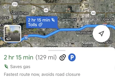
Have you noticed the “Saves gas” option in your Google Maps directions? Plug in a destination and you’ll likely receive several options, one of which will be labeled as the most fuel-efficient one.
According to an article by Justine Calma in The Verge, “Google uses a machine learning model to predict which route is the most fuel- or energy-efficient and recommends it to Maps users. If the most fuel-efficient route is also the fastest, Google Maps will default to that option.” The company says drivers have used these suggested routes to save roughly 1.2 million metric tons of carbon dioxide emissions since it launched the tool in 2021.
Users can also provide additional information, such as whether they drive an electric car, to get more accurate results. “To be sure, taking public transit, biking, or walking are still more sustainable alternatives, and Google says it’s working to make Maps easier to use outside of driving.”
Calma points out that “Google produces exponentially more pollution than any household, of course. Its carbon footprint added up to more than 10.18 million metric tons of CO2 emitted in 2022, roughly equivalent to pollution from more than 25 gas-fired power plants in a year.”
FULL STORY: People are using Google Maps to cut down tailpipe pollution


Toyota’s Hybrid Popularity Outpaces Production Worldwide
Soaring global demand for Toyota's hybrid vehicles is straining the automaker’s supply chain, leading to widespread delays as component shortages and limited production capacity challenge its ability to keep up.
Report: 14 States Increased Per-Capita Carbon Emissions
Many of the states on the list are red-leaning states that fought against federal environmental reporting regulations.

Report: Some Rural States Ahead of More Urbanized Ones in Reducing Transportation Emissions
This is a largely unintended consequence of states with lower populations and resources focusing on repairing existing roads and infrastructure rather than expanding and building new roads.

Maui's Vacation Rental Debate Turns Ugly
Verbal attacks, misinformation campaigns and fistfights plague a high-stakes debate to convert thousands of vacation rentals into long-term housing.

Planetizen Federal Action Tracker
A weekly monitor of how Trump’s orders and actions are impacting planners and planning in America.

San Francisco Suspends Traffic Calming Amidst Record Deaths
Citing “a challenging fiscal landscape,” the city will cease the program on the heels of 42 traffic deaths, including 24 pedestrians.

Adaptive Reuse Will Create Housing in a Suburban Texas Strip Mall
A developer is reimagining a strip mall property as a mixed-use complex with housing and retail.

Study: Anti-Homelessness Laws Don’t Work
Research shows that punitive measures that criminalized unhoused people don’t help reduce homelessness.

In U.S., Urban Gondolas Face Uphill Battle
Cities in Latin America and Europe have embraced aerial transitways — AKA gondolas — as sustainable, convenient urban transport, especially in tricky geographies. American cities have yet to catch up.
Urban Design for Planners 1: Software Tools
This six-course series explores essential urban design concepts using open source software and equips planners with the tools they need to participate fully in the urban design process.
Planning for Universal Design
Learn the tools for implementing Universal Design in planning regulations.
Heyer Gruel & Associates PA
JM Goldson LLC
Custer County Colorado
City of Camden Redevelopment Agency
City of Astoria
Transportation Research & Education Center (TREC) at Portland State University
Jefferson Parish Government
Camden Redevelopment Agency
City of Claremont