


Supporters of the waterfront park worry NYCDOT’s plan to potentially widen the Brooklyn-Queens Expressway could reduce green space in “one of the most expensive urban parks ever built.”
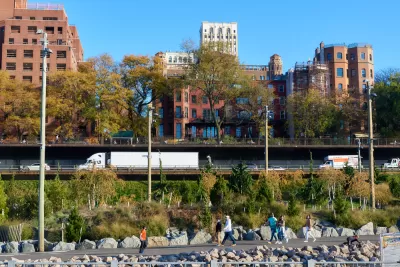
If the New York City Department of Transportation goes ahead with a proposal to expand the Brooklyn-Queens Expressway, known locally as the BQE, to three lanes in each direction, the road could cut into green space now part of the Brooklyn Bridge Park, reports Kevin Duggan for Streetsblog NYC.
The park, an 85-acre space completed between 2010 and 2021, is “one of the most expensive urban parks ever built” at $400 million. Former Traffic Commissioner San Schwartz and former Transportation Commissioner Hank Gutman both made public comments signaling their concern for the park and how an expanded highway footprint would damage the green space created by it.
DOT’s plans aren’t entirely clear, Duggan writes. While “DOT’s conceptual renderings of a future highway do indeed show substantial new open spaces covering the roadways and sloping down to Brooklyn Bridge Park,” the renderings show a 40-foot-wide highway, which would only accommodate two lanes in each direction. Yet in a December statement, DOT said the agency anticipates that their analysis “will result in three lanes of traffic.”
An analysis conducted by Schwartz’s firm three years ago “found the roadway could work with just two lanes if officials tried to discourage driving by closing some ramps or limiting them to high-occupancy vehicles, or by charging to cross the East River bridges at the same rates as the tolled Hugh Carey Tunnel.” A spokesperson for the park says “park officials had been assured the repairs would not reduce green space.”
FULL STORY: Wider BQE Could Be ‘Intrusion’ on Brooklyn Bridge Park, Ex-Transportation Leaders Warn


Which Ambitious Renovation Plan for the BQE?
The Brooklyn-Queens Expressway needs work, but the various proposals have very different visions about how to tackle the project and what the final outcome will be.
Preventing Crime, One Park at a Time
Deborah Marton, executive director of the New York Restoration Project, connects parks and open space to improved public safety.
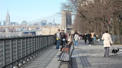
Fate of Brooklyn Heights Promenade Tethered to BQE Repair
The Brooklyn Heights Promenade will be closed as the Brooklyn-Queens Expressway below it is replaced. A Brownstoner column celebrates the esplanade's 68th birthday on Oct. 7, noting its troubled past and connection to Robert Moses.

Planetizen Federal Action Tracker
A weekly monitor of how Trump’s orders and actions are impacting planners and planning in America.

San Francisco's School District Spent $105M To Build Affordable Housing for Teachers — And That's Just the Beginning
SFUSD joins a growing list of school districts using their land holdings to address housing affordability challenges faced by their own employees.

The Tiny, Adorable $7,000 Car Turning Japan Onto EVs
The single seat Mibot charges from a regular plug as quickly as an iPad, and is about half the price of an average EV.

With Protected Lanes, 460% More People Commute by Bike
For those needing more ammo, more data proving what we already knew is here.

In More Metros Than You’d Think, Suburbs are Now More Expensive Than the City
If you're moving to the burbs to save on square footage, data shows you should think again.

The States Losing Rural Delivery Rooms at an Alarming Pace
In some states, as few as 9% of rural hospitals still deliver babies. As a result, rising pre-term births, no adequate pre-term care and "harrowing" close calls are a growing reality.
Urban Design for Planners 1: Software Tools
This six-course series explores essential urban design concepts using open source software and equips planners with the tools they need to participate fully in the urban design process.
Planning for Universal Design
Learn the tools for implementing Universal Design in planning regulations.
Smith Gee Studio
City of Charlotte
City of Camden Redevelopment Agency
City of Astoria
Transportation Research & Education Center (TREC) at Portland State University
US High Speed Rail Association
City of Camden Redevelopment Agency
Municipality of Princeton (NJ)