


The region around Vancouver in British Columbia has a new 30-year regional plan.
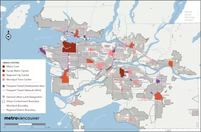
The Vancouver, British Columbia region wrapped up a major long-range planning initiative, titled Metro 2050, at the end of February. The region updates its long-range plan every ten years.
“Metro Vancouver has passed its regional growth strategy for the next 30 years, based on estimates that a million more people will be calling this region home by 2050,” reports Joanne Lee-Young for the Vancouver Sun.
“The years-long process for updating the Metro Vancouver region’s master plan, now called Metro 2050, culminated with Friday’s final approval of the strategy by Metro Vancouver Regional District’s board of directors, comprised of the region’s elected municipal officials,” reports Kenneth Chan for the Daily Hive in an article that headlines the plans focus on transit oriented development and new housing options
“The newly revised livable region strategic plan differentiates from past plans by focusing on adding much-needed housing supply to the region — a wide range of housing types for different incomes, especially rental housing, and the generation of such new housing supply through transit-oriented development,” adds Chan.
The Metro 2050 website lists five goals for the plan:
- Create a compact urban area
- Support a sustainable economy
- Protecting the environment, address change, and respond to natural hazards
- Provide diverse and affordable housing choices
- Support sustainable transportation choices
The website also notes that the plan does not change any boundaries on regional land use designations or the region’s Urban Containment Boundary (i.e., Vancouver’s version of urban growth boundaries).
FULL STORY: Metro Vancouver approves regional plan focused on transit-oriented housing

New Transit Oriented Zoning Criteria Proposed for Massachusetts
More details on the state of Massachusetts' game changing "Housing Choice" program are now available.
Central Maryland Regional Transit Plan: First Regional Transit Plan for Baltimore Since 2002
Transit planners in the Baltimore area are working on plans for a more reliable, useful regional transit system.

Chicagoland's Regional Transportation Authority Helping Deliver Local TOD Results
The Regional Transportation Authority has been supporting transit oriented development planning processes in suburbs like Bartlett.

Montreal Mall to Become 6,000 Housing Units
Place Versailles will be transformed into a mixed-use complex over the next 25 years.

Planetizen Federal Action Tracker
A weekly monitor of how Trump’s orders and actions are impacting planners and planning in America.

DARTSpace Platform Streamlines Dallas TOD Application Process
The Dallas transit agency hopes a shorter permitting timeline will boost transit-oriented development around rail stations.

Philadelphia Swaps Car Lanes for Bikeways in Unanimous Vote
The project will transform one of the handful of streets responsible for 80% of the city’s major crashes.

Interactive Map Reveals America's “Shade Deserts”
Launched by UCLA and American Forests to combat heat-related deaths, the tool maps the shade infrastructure for over 360 U.S. cities.

Bicycles and Books — In Sacramento, Libraries Now Offer Both
Adult library card holders can check out e-bikes and e-trikes for up to one week.
Urban Design for Planners 1: Software Tools
This six-course series explores essential urban design concepts using open source software and equips planners with the tools they need to participate fully in the urban design process.
Planning for Universal Design
Learn the tools for implementing Universal Design in planning regulations.
City of Mt Shasta
City of Camden Redevelopment Agency
City of Astoria
Transportation Research & Education Center (TREC) at Portland State University
US High Speed Rail Association
City of Camden Redevelopment Agency
Municipality of Princeton (NJ)