


A grant-funded research team will evaluate solutions for shoring up the area’s flood protection strategies and improving access and service on the Blue Line for local residents.

A study by A Better City will examine how improving Boston’s Blue Line can help mitigate the effects of climate change and protect public transit infrastructure on the city’s east side from rising sea levels, reports Grecia White for Streetsblog Massachusetts.
“As one of the few ways people can access Boston proper from East Boston without a car, the Blue Line is a critical transportation corridor that’s vulnerable to climate-related impacts and also to socio-economic pressures like gentrification.” According to the article, “The project, Greening the Blue Line, a collaboration between ABC, Civic Space Collaborative, and Weston and Sampson, will be evaluating the potential for nature based solutions to protect critical transportation infrastructure from coastal and stormwater flooding, and uplift communities along the Blue Line and East Boston, according to [Kate Dineen, Executive Vice President of A Better City].”
The study will assess “nature based solutions” for managing flooding and protecting transit stations and infrastructure near two Blue Line stations, Wood Island and Orient Heights. “At the end of the project, the team will share conceptual design approaches such as sketches and renderings for nature based solutions that could be implemented in key areas near these stations to help mitigate coastal flooding.”
FULL STORY: Blue Line in East Boston Is the Focus of Ongoing Climate Change Mitigation Study

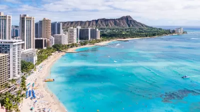
Rising Above: Innovative Solutions for Waikīkī’s Sea-Level Challenges
The University of Hawaiʻi at Mānoa’s award-winning Waikīkī sea-level rise adaptation project combines science, architecture, and community input to create scalable solutions for climate resilience and coastal flood mitigation.
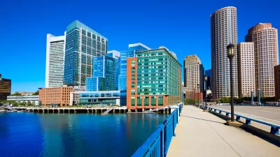
Boston’s Seaport District, Where Building Started Before Flood Preparation
The Boston waterfront has been booming, but the area is extremely vulnerable to climate change and rising sea levels. Measures to address those risks have come just recently.
How US Cities Can Prepare for Climate Disasters
Resilience, encompassing infrastructure, governance, economic strength, and social cohesion, is critical for cities to mitigate rising climate risks like flooding, wildfires, and heat, ensuring long-term recovery and adaptability.

Maui's Vacation Rental Debate Turns Ugly
Verbal attacks, misinformation campaigns and fistfights plague a high-stakes debate to convert thousands of vacation rentals into long-term housing.

Planetizen Federal Action Tracker
A weekly monitor of how Trump’s orders and actions are impacting planners and planning in America.

San Francisco Suspends Traffic Calming Amidst Record Deaths
Citing “a challenging fiscal landscape,” the city will cease the program on the heels of 42 traffic deaths, including 24 pedestrians.

Defunct Pittsburgh Power Plant to Become Residential Tower
A decommissioned steam heat plant will be redeveloped into almost 100 affordable housing units.

Trump Prompts Restructuring of Transportation Research Board in “Unprecedented Overreach”
The TRB has eliminated more than half of its committees including those focused on climate, equity, and cities.

Amtrak Rolls Out New Orleans to Alabama “Mardi Gras” Train
The new service will operate morning and evening departures between Mobile and New Orleans.
Urban Design for Planners 1: Software Tools
This six-course series explores essential urban design concepts using open source software and equips planners with the tools they need to participate fully in the urban design process.
Planning for Universal Design
Learn the tools for implementing Universal Design in planning regulations.
Heyer Gruel & Associates PA
JM Goldson LLC
Custer County Colorado
City of Camden Redevelopment Agency
City of Astoria
Transportation Research & Education Center (TREC) at Portland State University
Jefferson Parish Government
Camden Redevelopment Agency
City of Claremont