


A one-mile protected bike lane has been shown to decrease driver speeds and attract more cyclists to the route.
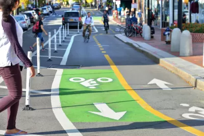
Data from a North Kansas City pilot project shows that adding a protected bike lane can play a significant role in reducing vehicle speeds and encouraging more biking. In addition to a one-mile protected bike lane on Armour Road in the summer of 2021, the city also added more visible crosswalks, landscaping, and pedestrian islands, writes Charles Pekow in Smart Cities Dive.
A study by Streetlight found that the number of cars going faster than 40 miles per hour on the mile-long stretch with a protected bike lane was reduced to almost zero. “Meanwhile, bike traffic more than doubled, from a daily average of 50 to 114. The report notes that bike traffic didn’t decrease on a parallel road that was used as a control for the project during that time, indicating that more people were riding, not transferring from nearby streets.”
The study did note that congestion worsened along the bike lane in the early part of the project, but started to dip in 2021.
FULL STORY: Protected bike lanes in North Kansas City slowed traffic, increased biking: study

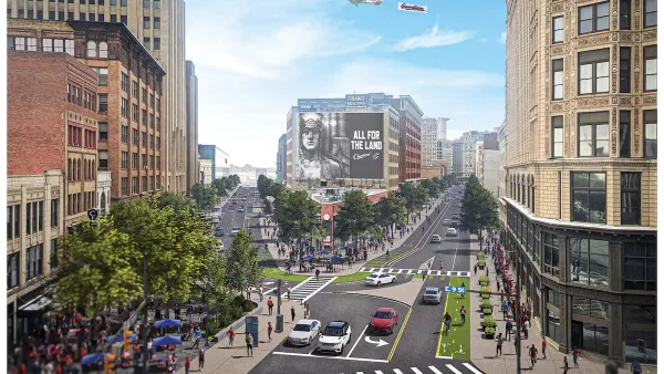
Downtown Cleveland Gets First Ever Protected Bike Lanes
The $200,000 “quick build” lanes are the first of 50 planned miles over five years.
Houston Mayor Promises Dedicated Austin Street Bike Lane After Public Backlash
Although the one-way bike lane won’t be protected by physical barriers, the proposal is an improvement over the mayor’s initial plan to only include sharrows on the Austin Street project.
A Troubling Trend of Backlash to Bike Lanes
Some cities are going so far as to rip out protected bike infrastructure that took years of advocacy to build.

Montreal Mall to Become 6,000 Housing Units
Place Versailles will be transformed into a mixed-use complex over the next 25 years.

Planetizen Federal Action Tracker
A weekly monitor of how Trump’s orders and actions are impacting planners and planning in America.

DARTSpace Platform Streamlines Dallas TOD Application Process
The Dallas transit agency hopes a shorter permitting timeline will boost transit-oriented development around rail stations.

Without International Immigrants, the Rural US Population Would Be Falling 58%
Census data shows that population growth in rural areas is due in large part to international migrants.

Dead End: Nine Highways Ready for Retirement
The Freeways Without Futures report describes the nation’s most promising highway removal proposals.

Congressman Proposes Bill to Rename DC Metro “Trump Train”
The Make Autorail Great Again Act would withhold federal funding to the system until the Washington Metropolitan Area Transit Authority (WMATA), rebrands as the Washington Metropolitan Authority for Greater Access (WMAGA).
Urban Design for Planners 1: Software Tools
This six-course series explores essential urban design concepts using open source software and equips planners with the tools they need to participate fully in the urban design process.
Planning for Universal Design
Learn the tools for implementing Universal Design in planning regulations.
City of Mt Shasta
City of Camden Redevelopment Agency
City of Astoria
Transportation Research & Education Center (TREC) at Portland State University
City of Camden Redevelopment Agency
Municipality of Princeton (NJ)
Regional Transportation Commission of Southern Nevada