


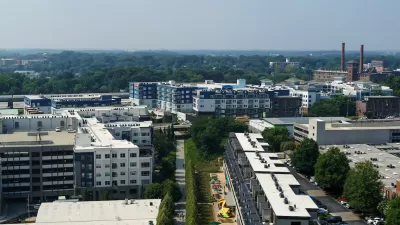
A new way of keeping track of the changes caused by one of the nation's "most ambitious urban redevelopment projects."

Josh Green shares news of an interactive data mapping tool published online by the Atlanta Beltline in partnership with Neighborhood Nexus.
Atlanta BeltLine has published two maps—the Investment Data Explorer and the Demographic Data Explorer. Together, according to Green, the maps are "convenient means of keeping tabs on changes brought, in part, by one of America’s most ambitious urban redevelopment projects."
The Investment Data Explorer, "drills down on funding and progress across BeltLine subareas related to parks, housing, trails, transit and streetscapes, and arts and culture," explains Green. The Demographic Data Explorer "vividly illustrates shifts in population densities, incomes, rent growth, and other metrics since the BeltLine’s conception."
The source article below provides more background and insight into the interactive data tools.
FULL STORY: Atlanta BeltLine launches gentrification-o-meter to track changes

New Study Commissioned for Atlanta BeltLine Transit
The study will assess alignment options for a 13-mile segment of the greenway.

Atlanta Streetcar Expansion Still Moving Forward
MARTA has drastically reduced its plans to construct new rail transit, but one project still has political support from the top at City Hall.

Final Piece of Atlanta BeltLine’s Route Falls Into Place
The choice of a route for the final segment of the Northwest Trail completes the planned route for the entire 22-mile length of the Atlanta BeltLine.

Planetizen Federal Action Tracker
A weekly monitor of how Trump’s orders and actions are impacting planners and planning in America.

Maui's Vacation Rental Debate Turns Ugly
Verbal attacks, misinformation campaigns and fistfights plague a high-stakes debate to convert thousands of vacation rentals into long-term housing.

San Francisco Suspends Traffic Calming Amidst Record Deaths
Citing “a challenging fiscal landscape,” the city will cease the program on the heels of 42 traffic deaths, including 24 pedestrians.

Defunct Pittsburgh Power Plant to Become Residential Tower
A decommissioned steam heat plant will be redeveloped into almost 100 affordable housing units.

Trump Prompts Restructuring of Transportation Research Board in “Unprecedented Overreach”
The TRB has eliminated more than half of its committees including those focused on climate, equity, and cities.

Amtrak Rolls Out New Orleans to Alabama “Mardi Gras” Train
The new service will operate morning and evening departures between Mobile and New Orleans.
Urban Design for Planners 1: Software Tools
This six-course series explores essential urban design concepts using open source software and equips planners with the tools they need to participate fully in the urban design process.
Planning for Universal Design
Learn the tools for implementing Universal Design in planning regulations.
Heyer Gruel & Associates PA
JM Goldson LLC
Custer County Colorado
City of Camden Redevelopment Agency
City of Astoria
Transportation Research & Education Center (TREC) at Portland State University
Jefferson Parish Government
Camden Redevelopment Agency
City of Claremont