


The United States has a long and insidious history of erecting structures to control the movements of African Americans in urban and suburban spaces.

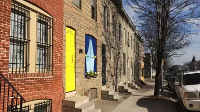
Chat Travieso writes about the history of walls and other barriers—fences, barricades, buffer strips—that have been used to segregate communities in cities across the country. "Under pretexts of traffic control, crime prevention, and protection of property values, municipalities from Florida to New York to California continue, into the present century, to block streets along Black-white neighborhood borders — and in so doing to further harden racial divisions, facilitate police intimidation, and force Black residents to take circuitous routes to get to work and school and to fulfill other daily needs."
Travieso has been mapping and documenting these representations of racial inequality manifested in the built environment. He recounts the histories of these structures, many of which still exist in some form, and their long-term impacts:
In Melbourne, Florida, a half-mile concrete wall separating the predominantly white Sunwood Park from the majority African-American Booker T. Washington area continues to block a direct path to the elementary school. The developer of Sunwood Park built the wall in 1959 in opposition to the county’s plan to construct a public-housing project. But, as I was told in 2019 by a community member named Pauline Clark, "to this day, no school buses come around here."
Private developers, civic authorities, and white homeowners were all complicit in using these barriers to segregate and disenfranchise African Americans. While their removal is one response, some communities have chosen to acknowledge the barriers as relics of racism and to reclaim the past through plaques, murals, and historic designations, says Travieso.
FULL STORY: A Nation of Walls


Improving Housing Through Trauma-Informed Design
A growing awareness of the link between the built environment and mental health has led some designers to examine the ways we can make housing feel more safe and welcoming for vulnerable populations.
Baltimore Confronts Underinvestment in Communities of Color
As part of an interdepartmental effort, the city's planning department is embedding an explicit equity lens into how it considers the distribution of civic resources.
Do Good Fences Make Good Neighborhood Parks?
A Chicago city park, recently redesigned to be more welcoming, could become less so in its final form. Neighbors complaining about "really shady" park visitors are lobbying for a 6-foot fence to be included in the park's multi-million dollar revamp.

Planetizen Federal Action Tracker
A weekly monitor of how Trump’s orders and actions are impacting planners and planning in America.

Congressman Proposes Bill to Rename DC Metro “Trump Train”
The Make Autorail Great Again Act would withhold federal funding to the system until the Washington Metropolitan Area Transit Authority (WMATA), rebrands as the Washington Metropolitan Authority for Greater Access (WMAGA).

DARTSpace Platform Streamlines Dallas TOD Application Process
The Dallas transit agency hopes a shorter permitting timeline will boost transit-oriented development around rail stations.

San Francisco's School District Spent $105M To Build Affordable Housing for Teachers — And That's Just the Beginning
SFUSD joins a growing list of school districts using their land holdings to address housing affordability challenges faced by their own employees.

Car-Centric LA Suburb Looks to a Train-Oriented Future
City leaders in Rancho Cucamonga, the future western terminus of the Brightline West rail line to Las Vegas, want to reimagine the city as a transit-oriented, pedestrian-friendly community.

New Alaska Bitcoin Mine Would Burn as Much Energy as the State’s Largest Coal Plant
Fueled by “stranded” natural gas, the startup hopes to become the largest in the US, and to make Alaska an industry center.
Urban Design for Planners 1: Software Tools
This six-course series explores essential urban design concepts using open source software and equips planners with the tools they need to participate fully in the urban design process.
Planning for Universal Design
Learn the tools for implementing Universal Design in planning regulations.
Municipality of Princeton
Roanoke Valley-Alleghany Regional Commission
City of Mt Shasta
City of Camden Redevelopment Agency
City of Astoria
Transportation Research & Education Center (TREC) at Portland State University
US High Speed Rail Association
City of Camden Redevelopment Agency
Municipality of Princeton (NJ)