


A new study published in the Land Use Policy journal explains how Houston's rapid expansion occurred, and why it matters.

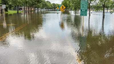
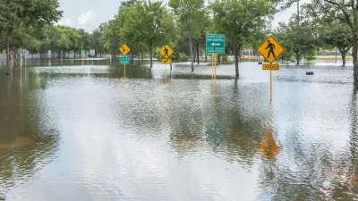
"The urban footprint of the Houston metropolitan area increased by 63% from 1997 to 2017," according to an article by Kevin T. Smiley and Christopher R. Hakkenberg. All that development added 1,000 km2 of impervious surfaces, a mind boggling total equivalent to 1.25 times the land area of New York City; a land area larger than the cities of Boston, Philadelphia, Pittsburgh, and Washington D.C. combined; and 186,873 football fields.
Smiley and Hakenberg, a sociologist and ecologist, respectively, explain their recent study in the Land Use Policy journal, which accounts for the social dynamics driving Houston's incredible expansion. The research integrates insights from each of the writer's respective disciplinary fields "to examine how the social characteristics of neighborhoods relate to how human beings alter their local environment."
The research produces two key findings, according to this article. The first finding came after analyzing urbanization Houston from 1997 to 2016:
If a neighborhood was adding college educated and employed residents or adding owner-occupied homes with higher overall home values, then it was more likely to be urbanizing rapidly — and adding impervious surfaces.
The second finding came after looking at the overall layout of Houston’s urban land, "not just the recent changes, but impervious surfaces created at any time":
Instead of socioeconomic status driving urbanization, we found that neighborhoods with more white residents tended to have higher levels of impervious surfaces. This was true in both 1997 and 2016, meaning that the new 1,000 square kilometers of urbanization didn’t change the overall trend.
So, the understanding of the social dynamics driving urban expansion changes depending whether the changes are evaluated over space or over time. This key distinction informs the authors' call for a new approach to land use and development in the face of the environmental threats presented by climate change.
FULL STORY: The rapid urbanization of Houston: how it happened and why it matters

Assessing Houston’s ‘Climate Abandonment Areas’
Most of the census tracts designated at high risk of flooding are in less affluent neighborhoods.
Five Key Takeaways from the 2018 World Urban Forum
Insight into the hard work of implementing the New Urban Agenda.
Houston Flooding: Climate Change or Development Patterns to Blame?
The Guardian's former environmental editor asks if urban sprawl is as much to blame as climate change for the flooding caused by Hurricane Harvey in Houston.

Maui's Vacation Rental Debate Turns Ugly
Verbal attacks, misinformation campaigns and fistfights plague a high-stakes debate to convert thousands of vacation rentals into long-term housing.

Planetizen Federal Action Tracker
A weekly monitor of how Trump’s orders and actions are impacting planners and planning in America.

San Francisco Suspends Traffic Calming Amidst Record Deaths
Citing “a challenging fiscal landscape,” the city will cease the program on the heels of 42 traffic deaths, including 24 pedestrians.

Half of Post-Fire Altadena Home Sales Were to Corporations
Large investors are quietly buying up dozens of properties in Altadena, California, where a devastating wildfire destroyed more than 6,000 homes in January.

Opinion: What San Francisco’s Proposed ‘Family Zoning’ Could Really Mean
Mayor Lurie is using ‘family zoning’ to encourage denser development and upzoning — but could the concept actually foster community and more human-scale public spaces?

Jacksonville Launches First Autonomous Transit Shuttle in US
A fleet of 14 fully autonomous vehicles will serve a 3.5-mile downtown Jacksonville route with 12 stops.
Urban Design for Planners 1: Software Tools
This six-course series explores essential urban design concepts using open source software and equips planners with the tools they need to participate fully in the urban design process.
Planning for Universal Design
Learn the tools for implementing Universal Design in planning regulations.
Gallatin County Department of Planning & Community Development
Heyer Gruel & Associates PA
JM Goldson LLC
City of Camden Redevelopment Agency
City of Astoria
Transportation Research & Education Center (TREC) at Portland State University
Jefferson Parish Government
Camden Redevelopment Agency
City of Claremont