


BikePortland publisher and editor-in-chief Jonathan Maus took a ride along two new neighborhood greenways to report on successes and opportunities for continued improvement.
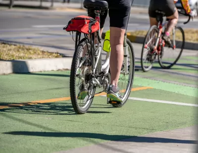
The Portland Bureau of Transportation recently completed almost seven miles of neighborhood greenway bike routes in East Portland, a part of the city that critically lacked bike infrastructure. Jonathan Maus took a bike tour of the “130s” and “HOP” projects, snapping photos along the way to illustrate the transformation.
"The lack of street grid and high speed of drivers makes every bike network investment important out there. While I focused on the crossings, what’s really great about these new greenways is how they will help people find their way between neighborhoods," Maus reflects.
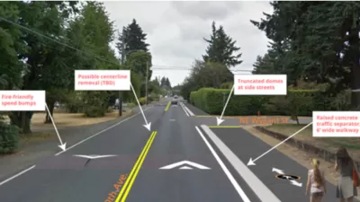
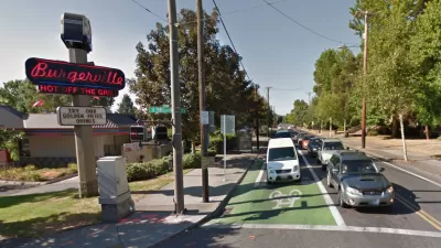
The "130s," a north-south route jogging between 128th and 132nd, spans the distance between SE Foster Road and I-84 in Northeast Portland. Maus sees a new signalized crosswalk median leading to a protected bike lane at Southeast Powell Boulevard as an improvement, noting that the Outer Powell Safety Project will further improve the protected lanes. Nearing East Burnside Boulevard, "The route took me onto the sidewalk following those green dots again and then directed me over the rail tracks via a narrow sidewalk hemmed in by railings," says Maus, sharing concern about the difficulty in crossing at this intersection housing the MAX light rail.
Heading west on the "HOP" (Hassalo/Holladay-Oregon-Pacific) greenway, Maus navigated to the Gateway Transit center. "I found the eastern end of the HOP disappointing. I didn’t find any clear connection to the transit center itself. I mean, this is a major transit center and the bikeway just seemed to fizzle out," Maus says.
Among key takeaways from the ride, Maus cites inconsistencies in sidewalk routing treatments and proximity to high-speed traffic on arterials. " It doesn’t matter how good our low-stress greenways are if the crossings are high-stress. A chain is only as strong as its weakest link, remember?"
FULL STORY: Taking a ride on east Portland’s new neighborhood greenways


Portland and Multnomah County Push for Lower Speed Limits on Bridges
The Portland Bureau of Transportation and Multnomah County agree on a 30 mph speed limit on five downtown bridges, but the state's department of transportation denied the change on two key spans.
Portland Installs 'Alternative Pedestrian Walkway'
The walkway is simpler and faster to build than a sidewalk, letting the city quickly and cost-effectively improve pedestrian safety on important walking corridors.
Making Protected Bike Lanes the Design Standard
An institutional mandate isn't enough to make a design vision a reality. Portland is working on bringing its standards and guidelines in line with its ambition for protected bike lanes.

Planetizen Federal Action Tracker
A weekly monitor of how Trump’s orders and actions are impacting planners and planning in America.

Congressman Proposes Bill to Rename DC Metro “Trump Train”
The Make Autorail Great Again Act would withhold federal funding to the system until the Washington Metropolitan Area Transit Authority (WMATA), rebrands as the Washington Metropolitan Authority for Greater Access (WMAGA).

DARTSpace Platform Streamlines Dallas TOD Application Process
The Dallas transit agency hopes a shorter permitting timeline will boost transit-oriented development around rail stations.

Supreme Court Ruling in Pipeline Case Guts Federal Environmental Law
The decision limits the scope of a federal law that mandates extensive environmental impact reviews of energy, infrastructure, and transportation projects.

Texas State Bills to Defund Dallas Transit Die
DART would have seen a 30% service cut, $230M annual losses had the bills survived.

Bikeshare for the Win: Team Pedals to London Cricket Match, Beats Rivals Stuck in Traffic
While their opponents sat in gridlock, England's national cricket team hopped Lime bikes, riding to a 3-0 victory.
Urban Design for Planners 1: Software Tools
This six-course series explores essential urban design concepts using open source software and equips planners with the tools they need to participate fully in the urban design process.
Planning for Universal Design
Learn the tools for implementing Universal Design in planning regulations.
Roanoke Valley-Alleghany Regional Commission
City of Mt Shasta
City of Camden Redevelopment Agency
City of Astoria
Transportation Research & Education Center (TREC) at Portland State University
US High Speed Rail Association
City of Camden Redevelopment Agency
Municipality of Princeton (NJ)