


The walkway is simpler and faster to build than a sidewalk, letting the city quickly and cost-effectively improve pedestrian safety on important walking corridors.
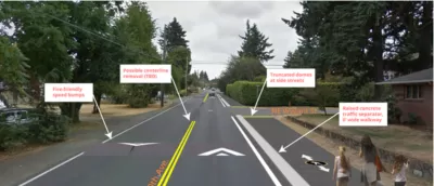
The city of Portland is experimenting with a new type of pedestrian walkway that could "improve walking conditions without the expense or complication of building a full-fledged sidewalk." Jonathan Maus of Bike Portland reports on the "alternative pedestrian walkway," a one-mile pilot project on Portland's Northeast 60th Avenue.
"Identified as a major walking corridor in the city’s pedestrian master plan (Ped PDX, 2019), 60th was like many streets in Cully and other less-developed parts of Portland: it had two general lanes and no space for shoulders, bike lanes or sidewalks. To get the space for a six-foot wide walkway on one side of the street, PBOT shifted the centerline over about four feet. They then leveled and paved the existing gravel shoulder." The walkway is marked with pedestrian markings and crossings feature "zebra-striping, truncated domes (those tiny yellow bumps), and a few plastic delineator wands."
Although not designed as a bikeway, use by bicycles is allowed. "Until PBOT establishes good bikeways nearby, this could become a useful bikeway." The project provides a template for quick, low-cost pedestrian improvements.
FULL STORY: First Look: Portland’s novel ‘alternative pedestrian walkway’


Portland Council Tentatively Approves Sidewalk Repair Plan
The proposal would address sidewalk needs in Portland’s District 1 and District 4.

Portland Transportation Bureau Faces ‘Existential’ Cuts
PBOT’s director says the agency’s impending budget shortfall could imperil even basic transportation and infrastructure services.

Audit: Portland’s Vision Zero Needs More Data, Funding
A city audit found that the program has failed to reduce traffic deaths and could benefit from a more systematic approach. Meanwhile, PBOT says it needs more state funding to support road safety projects.

Maui's Vacation Rental Debate Turns Ugly
Verbal attacks, misinformation campaigns and fistfights plague a high-stakes debate to convert thousands of vacation rentals into long-term housing.

Planetizen Federal Action Tracker
A weekly monitor of how Trump’s orders and actions are impacting planners and planning in America.

In Urban Planning, AI Prompting Could be the New Design Thinking
Creativity has long been key to great urban design. What if we see AI as our new creative partner?

King County Supportive Housing Program Offers Hope for Unhoused Residents
The county is taking a ‘Housing First’ approach that prioritizes getting people into housing, then offering wraparound supportive services.

Researchers Use AI to Get Clearer Picture of US Housing
Analysts are using artificial intelligence to supercharge their research by allowing them to comb through data faster. Though these AI tools can be error prone, they save time and housing researchers are optimistic about the future.

Making Shared Micromobility More Inclusive
Cities and shared mobility system operators can do more to include people with disabilities in planning and operations, per a new report.
Urban Design for Planners 1: Software Tools
This six-course series explores essential urban design concepts using open source software and equips planners with the tools they need to participate fully in the urban design process.
Planning for Universal Design
Learn the tools for implementing Universal Design in planning regulations.
planning NEXT
Appalachian Highlands Housing Partners
Mpact (founded as Rail~Volution)
City of Camden Redevelopment Agency
City of Astoria
City of Portland
City of Laramie