


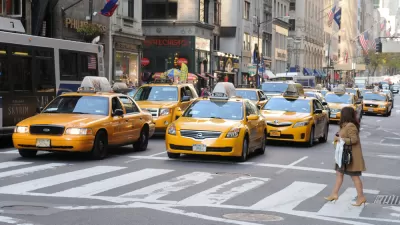
Many of the places in Chicago generating the most ride-hailing trips with services like Uber and Lyft are accessible by transit, according to new research.

Oriol Marquet, a researcher from the University of Barcelona, has published new research on the effect of land use at trip origin and destination on demand for ride-hailing services like Uber and Lyft.
The paper, titled "Spatial distribution of ride-hailing trip demand and its association with walkability and neighborhood characteristics" and published recently by the journal Cities, examined records of 32 million ride-hailing trips in the city of Chicago to identify how land use determines the use of ride-hailing services.
According to a Tweet posted by Marquet, the paper identifies "worrisome trends," namely, that "61% of ride-hailing trips are between highly walkable areas," and areas that offer more sustainable forms of travel. As put in the paper's abstract, "Ride-hailing is predominantly being used to travel between highly accessible areas which should be accessed using more sustainable transport modes."
The paper adds a land use angle to previous research that found evidence that many ride-hailing trips are being made at the expense of transit trips, as first revealed by a study performed by Regina Clewlow in October 2017, and contributing to a decline in transit use in urban areas.
According to another Tweet by Marquet, "Ride hailing does not seem to be a viable alternative for low-income households or for those with no car access. This suggests that even at the currently heavily-subsidized low prices, Uber and Lyft cannot substitute for public transit in low-income areas." The trip data was generated between November 1, 2018 to June 28, 2019, so the research comes with the caveat that the data and findings reflect mode choices and trip generation in the time before coronavirus.

Ride-Hailing Prices Skyrocket as the U.S. Emerges From the Pandemic
A shortage of drivers and spiking demand are driving Uber and Lyft prices higher than ever as the companies struggle to achieve profitability.

Ride-Hailing Companies Eye Public Transit Opportunities for the Wrong Reasons
Uber and Lyft say they want to improve public transit, but the focus on profit could have serious consequences.
Study: Uber and Lyft Have Been Catastrophic for Public Transit Ridership
The most damning evidence yet of how ride hailing is making urban transportation less efficient, not more.

Maui's Vacation Rental Debate Turns Ugly
Verbal attacks, misinformation campaigns and fistfights plague a high-stakes debate to convert thousands of vacation rentals into long-term housing.

Planetizen Federal Action Tracker
A weekly monitor of how Trump’s orders and actions are impacting planners and planning in America.

In Urban Planning, AI Prompting Could be the New Design Thinking
Creativity has long been key to great urban design. What if we see AI as our new creative partner?

King County Supportive Housing Program Offers Hope for Unhoused Residents
The county is taking a ‘Housing First’ approach that prioritizes getting people into housing, then offering wraparound supportive services.

Researchers Use AI to Get Clearer Picture of US Housing
Analysts are using artificial intelligence to supercharge their research by allowing them to comb through data faster. Though these AI tools can be error prone, they save time and housing researchers are optimistic about the future.

Making Shared Micromobility More Inclusive
Cities and shared mobility system operators can do more to include people with disabilities in planning and operations, per a new report.
Urban Design for Planners 1: Software Tools
This six-course series explores essential urban design concepts using open source software and equips planners with the tools they need to participate fully in the urban design process.
Planning for Universal Design
Learn the tools for implementing Universal Design in planning regulations.
planning NEXT
Appalachian Highlands Housing Partners
Mpact (founded as Rail~Volution)
City of Camden Redevelopment Agency
City of Astoria
City of Portland
City of Laramie