


Heatwaves are the leading cause of deaths related to weather. A new study seeks to understand the impact of heatwaves and extreme heat exposure on humans and the cities in which they live.

"The motley drivers of heat and cold exposure in 21st century US cities," a paper published by the Proceedings of the National Academy of Sciences (PNAS), reports on the findings of a new study about human exposure to extreme heat.
To humanize the research, the study reports impact in terms of person-hours: the number of hours of intense exposure experienced by humans.
"Overall, the researchers found that the average annual heat exposure at the start of this century in the United States was about 5.2 billion person-hours. They calculated that assuming a worst-case scenario of peak global warming, population growth and urban development, the annual heat exposure would rise to 150 billion person-hours by the end of the century, a nearly 30-fold increase," writes Sarah Wray.
The Arizona State University researchers responsible for the study make use of a climate change modeling approach to better understand the influence of climate change on cities. In the United States, sunbelt cities were found to be the worst affected cities.
Wray's article summarizes the key takeaways from the research and makes suggestions about how cities can increase their resiliency in the face of climate change. Wray also notes that the researchers are working on a followup paper to communicate "city-specific estimates of the avoided heat exposure derived from urban adaptation measures and greenhouse mitigation."
FULL STORY: Study highlights US cities at risk of rising heat exposure


U.S. Communities Increasingly at Risk of Extreme Weather Events
As development pushes into more wildfire-prone areas and climate change makes extreme weather conditions more common, more Americans are experiencing the destructive impacts of climate disasters.
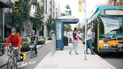
As Heat Waves Become More Common, Bus Shelters Are Needed to Keep Transit Riders Onboard
As climate change brings prolonged, intense heat waves to cities once associated with rain and cold weather will have to attend to the lack of shelter provided to bus and transit riders.

Key Climate and Health Issues to Watch in 2025
The escalating health impacts of climate change, from extreme heat to sea level rise, highlight the urgent need for integrated medical education, proactive communication, and sustainable policy solutions to protect public health.

Planetizen Federal Action Tracker
A weekly monitor of how Trump’s orders and actions are impacting planners and planning in America.

San Francisco's School District Spent $105M To Build Affordable Housing for Teachers — And That's Just the Beginning
SFUSD joins a growing list of school districts using their land holdings to address housing affordability challenges faced by their own employees.

The Tiny, Adorable $7,000 Car Turning Japan Onto EVs
The single seat Mibot charges from a regular plug as quickly as an iPad, and is about half the price of an average EV.

With Protected Lanes, 460% More People Commute by Bike
For those needing more ammo, more data proving what we already knew is here.

In More Metros Than You’d Think, Suburbs are Now More Expensive Than the City
If you're moving to the burbs to save on square footage, data shows you should think again.

The States Losing Rural Delivery Rooms at an Alarming Pace
In some states, as few as 9% of rural hospitals still deliver babies. As a result, rising pre-term births, no adequate pre-term care and "harrowing" close calls are a growing reality.
Urban Design for Planners 1: Software Tools
This six-course series explores essential urban design concepts using open source software and equips planners with the tools they need to participate fully in the urban design process.
Planning for Universal Design
Learn the tools for implementing Universal Design in planning regulations.
Smith Gee Studio
City of Charlotte
City of Camden Redevelopment Agency
City of Astoria
Transportation Research & Education Center (TREC) at Portland State University
US High Speed Rail Association
City of Camden Redevelopment Agency
Municipality of Princeton (NJ)