


A new satellite, currently residing on the International Space Station and scheduled for deployment in January, will measure and map the urban heat island effect of seven U.S. cities.

Arizona State University students built a satellite named CubeSat that launched this month into space on an Antares rocket.
Ian James reports on the recent launch of the satellite, known as CubeSat, which measures only 12 inches long by 4 inches wide and weighed 8.6 pounds. Cubesat was engineered to capture block-by-block, infrared images of Phoenix and six other U.S. cities. The resulting data on heat trends "could help urban planners design cooler cityscapes to withstand the effects as the world continues to heat up due to the burning of fossil fuels," according to the article.
"Four years ago, the students wrote a proposal to build the satellite and obtained $200,000 in NASA funding," explains James of how the project came to be. "A total of about 80 undergraduate students took part in the project. Many of them spent long hours designing the spacecraft, piecing together the components, testing its systems, and writing code to make it all work."
"In addition to focusing on Phoenix, the plan is for the satellite to gather thermal images of Los Angeles, Chicago, Houston, Atlanta, Baltimore and Minneapolis," adds James, who also provides details of how the new data will be used to create new forms of climate mapping for the cities under study.
FULL STORY: Satellite built by students soars to space on mission to map heat in Phoenix, other cities

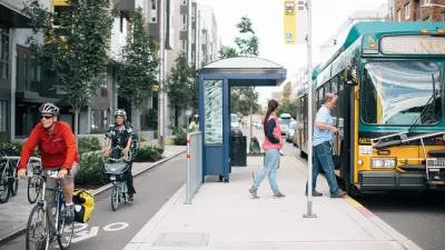
As Heat Waves Become More Common, Bus Shelters Are Needed to Keep Transit Riders Onboard
As climate change brings prolonged, intense heat waves to cities once associated with rain and cold weather will have to attend to the lack of shelter provided to bus and transit riders.

Planting Relief: Tackling Las Vegas Heat One Tree at a Time
Nevada Plants, a Las Vegas-based nonprofit, is combating the city’s extreme urban heat by giving away trees to residents in underserved neighborhoods, promoting shade, sustainability, and community health.

Key Climate and Health Issues to Watch in 2025
The escalating health impacts of climate change, from extreme heat to sea level rise, highlight the urgent need for integrated medical education, proactive communication, and sustainable policy solutions to protect public health.

Planetizen Federal Action Tracker
A weekly monitor of how Trump’s orders and actions are impacting planners and planning in America.

Congressman Proposes Bill to Rename DC Metro “Trump Train”
The Make Autorail Great Again Act would withhold federal funding to the system until the Washington Metropolitan Area Transit Authority (WMATA), rebrands as the Washington Metropolitan Authority for Greater Access (WMAGA).

The Simple Legislative Tool Transforming Vacant Downtowns
In California, Michigan and Georgia, an easy win is bringing dollars — and delight — back to city centers.

The States Losing Rural Delivery Rooms at an Alarming Pace
In some states, as few as 9% of rural hospitals still deliver babies. As a result, rising pre-term births, no adequate pre-term care and harrowing close calls are a growing reality.

The Small South Asian Republic Going all in on EVs
Thanks to one simple policy change less than five years ago, 65% of new cars in this Himalayan country are now electric.

DC Backpedals on Bike Lane Protection, Swaps Barriers for Paint
Citing aesthetic concerns, the city is removing the concrete barriers and flexposts that once separated Arizona Avenue cyclists from motor vehicles.
Urban Design for Planners 1: Software Tools
This six-course series explores essential urban design concepts using open source software and equips planners with the tools they need to participate fully in the urban design process.
Planning for Universal Design
Learn the tools for implementing Universal Design in planning regulations.
Smith Gee Studio
City of Charlotte
City of Camden Redevelopment Agency
City of Astoria
Transportation Research & Education Center (TREC) at Portland State University
US High Speed Rail Association
City of Camden Redevelopment Agency
Municipality of Princeton (NJ)