


Before drafting a new Pedestrian Master Plan for Montgomery County, planners are creating a detailed inventory of street conditions by walking every single one fo the county's roads and streets.
Montgomery County, Maryland is in the process of developing a Pedestrian Master Plan, as reported in September 2019.
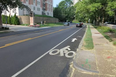
Now Sanjida Rangwala provides an update on the process, which includes a very notable step—actually a whole bunch of steps. To gather information on the safety of street conditions, Montgomery County employees are planning to walk every road and street in the county.
We wrote previously about the county’s #walkinghere campaign, which encourages residents to share the conditions of their walking trips on social media. Now county staff are documenting pedestrian experience throughout the county. They’re starting with major commercial areas, so your neighborhood might not have made it onto the survey yet. (Mine hasn’t). You can follow the progress of the map here.
Rangwala explains how the inventory of street conditions created by this survey process and provides photos to illustrate differences in classification. The article concludes with an appeal for safer streets in the county.
FULL STORY: Montgomery County planners will walk every street to see how safe they are for pedestrians


First for Montgomery County: A Pedestrian Master Plan
Planners in Montgomery County, Maryland, one of the most famous suburban regions in the country, will produce the first-ever pedestrian master plan for the county.
Pedestrian Planning in Response to Worsening Safety Data
Faced with rapidly deteriorating pedestrian safety statistics, Montgomery County in Maryland is getting to work on a new Pedestrian Plan, following closely on the heels of work completed for the county's Bicycle Master Plan.

Debunking Traffic Safety Myths as Pedestrian Fatalities Increase
Angie Schmitt, former editor at Streetsblog USA, has written a new book about pedestrian fatalities, which works to dispel some of the myths about traffic safety in the United States.

Planetizen Federal Action Tracker
A weekly monitor of how Trump’s orders and actions are impacting planners and planning in America.

Congressman Proposes Bill to Rename DC Metro “Trump Train”
The Make Autorail Great Again Act would withhold federal funding to the system until the Washington Metropolitan Area Transit Authority (WMATA), rebrands as the Washington Metropolitan Authority for Greater Access (WMAGA).

The Simple Legislative Tool Transforming Vacant Downtowns
In California, Michigan and Georgia, an easy win is bringing dollars — and delight — back to city centers.

The States Losing Rural Delivery Rooms at an Alarming Pace
In some states, as few as 9% of rural hospitals still deliver babies. As a result, rising pre-term births, no adequate pre-term care and "harrowing" close calls are a growing reality.

The Small South Asian Republic Going all in on EVs
Thanks to one simple policy change less than five years ago, 65% of new cars in this Himalayan country are now electric.

DC Backpedals on Bike Lane Protection, Swaps Barriers for Paint
Citing aesthetic concerns, the city is removing the concrete barriers and flexposts that once separated Arizona Avenue cyclists from motor vehicles.
Urban Design for Planners 1: Software Tools
This six-course series explores essential urban design concepts using open source software and equips planners with the tools they need to participate fully in the urban design process.
Planning for Universal Design
Learn the tools for implementing Universal Design in planning regulations.
Smith Gee Studio
City of Charlotte
City of Camden Redevelopment Agency
City of Astoria
Transportation Research & Education Center (TREC) at Portland State University
US High Speed Rail Association
City of Camden Redevelopment Agency
Municipality of Princeton (NJ)