


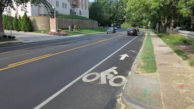
Planners in Montgomery County, Maryland, one of the most famous suburban regions in the country, will produce the first-ever pedestrian master plan for the county.

Montgomery County, Maryland has launched the process of writing its first ever pedestrian master plan, reports Mike Diegel.
The county's Planning Department kicked off the process with approval of a scope of work by the Planning Board on September 5. According to Diegel, the department will launch straight into a series of community meetings, and "[t]he plan is scheduled to be completed and approved in the summer of 2021."
An announcement of the new pedestrian planning effort describes the work in more detail:
The new pedestrian master plan, to be developed by Montgomery Planning’s Functional Planning and Policy Division, will address all reasons for walking – commuting to and from work or school, running errands, recreation, entertainment, exercise and everything in between. Planner recommendations will support making walking universally accessible to county residents of all ages and abilities and will consider walking by foot (including with a cane, a walker or a stroller), by wheelchair or by mobility scooter.
FULL STORY: PLANNING DEPARTMENT LAUNCHES FIRST PEDESTRIAN MASTER PLAN

On Foot: Planners Complete Street Safety Inventory One Step at a Time
Before drafting a new Pedestrian Master Plan for Montgomery County, planners are creating a detailed inventory of street conditions by walking every single one fo the county's roads and streets.

Pedestrian Planning in Response to Worsening Safety Data
Faced with rapidly deteriorating pedestrian safety statistics, Montgomery County in Maryland is getting to work on a new Pedestrian Plan, following closely on the heels of work completed for the county's Bicycle Master Plan.
Implementing Seattle's Pedestrian Master Plan
The Seattle Department of Transportation has released a five-year roadmap for implementing the city of Seattle's Pedestrian Master Plan (PMP).

Planetizen Federal Action Tracker
A weekly monitor of how Trump’s orders and actions are impacting planners and planning in America.

Chicago’s Ghost Rails
Just beneath the surface of the modern city lie the remnants of its expansive early 20th-century streetcar system.

San Antonio and Austin are Fusing Into one Massive Megaregion
The region spanning the two central Texas cities is growing fast, posing challenges for local infrastructure and water supplies.

Since Zion's Shuttles Went Electric “The Smog is Gone”
Visitors to Zion National Park can enjoy the canyon via the nation’s first fully electric park shuttle system.

Trump Distributing DOT Safety Funds at 1/10 Rate of Biden
Funds for Safe Streets and other transportation safety and equity programs are being held up by administrative reviews and conflicts with the Trump administration’s priorities.

German Cities Subsidize Taxis for Women Amid Wave of Violence
Free or low-cost taxi rides can help women navigate cities more safely, but critics say the programs don't address the root causes of violence against women.
Urban Design for Planners 1: Software Tools
This six-course series explores essential urban design concepts using open source software and equips planners with the tools they need to participate fully in the urban design process.
Planning for Universal Design
Learn the tools for implementing Universal Design in planning regulations.
planning NEXT
Appalachian Highlands Housing Partners
Mpact (founded as Rail~Volution)
City of Camden Redevelopment Agency
City of Astoria
City of Portland
City of Laramie