


Google Maps will now share data about how crowded buses and trains are likely to be.
Google has been collecting data on how many people are on trains and buses around the country, and now it's ready to share that data with Google Maps users. "Google is basing these details on past rides. For months, Google has been asking some people who use Google Maps to provide additional details about the level of crowdedness of their transit trips," Andrew J. Hawkins reports for The Verge. While these predictions won’t be based on current conditions they’re likely to improve as the app collects more data.
"In addition, Google Maps is also launching live traffic delays for buses in places where commuters don’t already have real-time information direct from local transit agencies," Hawkins reports. While many large American cities already provide this information to their riders, it could be a big help to folks riding buses in smaller communities.
These improvements to transit navigation, aren’t the only changes to Google’s navigation services, which have also added services for drivers and carpoolers.
FULL STORY: Google Maps is receiving major public transportation improvements


Suburban Detroit Achieves Long-Awaited Bus Service Expansion
Novi and Bloomfield Hills in Southeast Michigan will have transit service for the first time in 28 years.
The Bus Revolution Has Been Revised in Philadelphia
The Southeastern Pennsylvania Transportation Authority went back to the drawing board with its Bus Revolution system redesign after an initial round of feedback completed earlier this year.
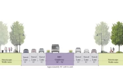
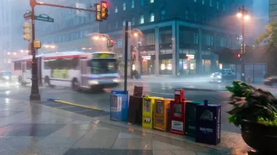
Fairfax County Makes Space for Bus Rapid Transit
A recent decision by the Fairfax, Virginia County Board of Supervisors will ensure that any widening of Route 7 will be reserved for bus rapid transit (BRT).

Planetizen Federal Action Tracker
A weekly monitor of how Trump’s orders and actions are impacting planners and planning in America.

Congressman Proposes Bill to Rename DC Metro “Trump Train”
The Make Autorail Great Again Act would withhold federal funding to the system until the Washington Metropolitan Area Transit Authority (WMATA), rebrands as the Washington Metropolitan Authority for Greater Access (WMAGA).

The Simple Legislative Tool Transforming Vacant Downtowns
In California, Michigan and Georgia, an easy win is bringing dollars — and delight — back to city centers.

The States Losing Rural Delivery Rooms at an Alarming Pace
In some states, as few as 9% of rural hospitals still deliver babies. As a result, rising pre-term births, no adequate pre-term care and harrowing close calls are a growing reality.

The Small South Asian Republic Going all in on EVs
Thanks to one simple policy change less than five years ago, 65% of new cars in this Himalayan country are now electric.

DC Backpedals on Bike Lane Protection, Swaps Barriers for Paint
Citing aesthetic concerns, the city is removing the concrete barriers and flexposts that once separated Arizona Avenue cyclists from motor vehicles.
Urban Design for Planners 1: Software Tools
This six-course series explores essential urban design concepts using open source software and equips planners with the tools they need to participate fully in the urban design process.
Planning for Universal Design
Learn the tools for implementing Universal Design in planning regulations.
Smith Gee Studio
City of Charlotte
City of Camden Redevelopment Agency
City of Astoria
Transportation Research & Education Center (TREC) at Portland State University
US High Speed Rail Association
City of Camden Redevelopment Agency
Municipality of Princeton (NJ)