


The San Francisco Bay has 400 miles of shoreline, and a dire need for a new approach to dealing with the effects of rising water levels. An estimated $100 billion in potential property damage is at risk.
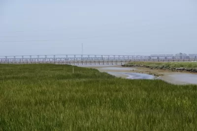
"A blueprint outlining how San Francisco Bay communities should combat sea-level rise was released early Thursday by ecosystem scientists and urban planners who envision a ring of man-made reefs, rocky beaches and graded marshlands around the largest estuary on the Pacific coast," reports Peter Fimrite.
The San Francisco Estuary Institute and SPUR created the San Francisco Bay Shoreline Adaptation Atlas [pdf], proposing major changes to existing seawalls, rip rap, culverts and other fortifications that are unlikely to weather the impacts of rising seas.
"The idea […] is to build eco-friendly features that support wildlife and absorb, rather than repel, the rising tides," explains Fimrite.
"The plan, funded by the San Francisco Bay Regional Water Quality Control Board, is the first attempt in the Bay Area to develop a collaborative regional plan to both enhance the ecosystem and protect cities around the bay from the potential ravages of climate change."

S.F. Plan Amendment to Allow Bay Filling
A revision to the region’s plan for the bay will allow areas to be filled in to create habitats that mitigate the effects of climate change.

Living Shorelines for Storm and Flood Protection
More coastal cities and communities are turning to the "soft" solutions of living shorelines—relying on "a combination of oyster reefs, oyster shells, rocks, marsh plants, and other natural materials can be an effective alternative to seawalls."
Bay Area Election Roundup: Wetlands, Housing, Ballot-Box Planning, Sales Tax
A regional measure to tax all property owners in the 9-county Bay Area to adapt to sea level rise passes; S.F. voters support raising the affordable housing bar; Richmond voters reject ballot-box planning; San José approves sales tax increase.

Planetizen Federal Action Tracker
A weekly monitor of how Trump’s orders and actions are impacting planners and planning in America.

San Francisco's School District Spent $105M To Build Affordable Housing for Teachers — And That's Just the Beginning
SFUSD joins a growing list of school districts using their land holdings to address housing affordability challenges faced by their own employees.

The Tiny, Adorable $7,000 Car Turning Japan Onto EVs
The single seat Mibot charges from a regular plug as quickly as an iPad, and is about half the price of an average EV.

With Protected Lanes, 460% More People Commute by Bike
For those needing more ammo, more data proving what we already knew is here.

In More Metros Than You’d Think, Suburbs are Now More Expensive Than the City
If you're moving to the burbs to save on square footage, data shows you should think again.

The States Losing Rural Delivery Rooms at an Alarming Pace
In some states, as few as 9% of rural hospitals still deliver babies. As a result, rising pre-term births, no adequate pre-term care and "harrowing" close calls are a growing reality.
Urban Design for Planners 1: Software Tools
This six-course series explores essential urban design concepts using open source software and equips planners with the tools they need to participate fully in the urban design process.
Planning for Universal Design
Learn the tools for implementing Universal Design in planning regulations.
Smith Gee Studio
City of Charlotte
City of Camden Redevelopment Agency
City of Astoria
Transportation Research & Education Center (TREC) at Portland State University
US High Speed Rail Association
City of Camden Redevelopment Agency
Municipality of Princeton (NJ)