


Cities across the country are developing floodplain construction standards that are more stringent than those required by FEMA.

James Bruggers reports that a number of cities are trying to get ahead of the threat of flooding by putting building standards in place that exceed federal ones. "Hundreds of communities and as many as 22 states already require new construction be elevated higher than federal requirements in the high-risk 100-year floodplain, which is based on a 1 percent chance of flooding in any given year."
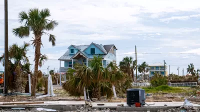
Some local municipalities, however, are going even further by applying the standards to buildings in the 500-year floodplain, where flood insurance is voluntary. For example, Mexico Beach, Florida, found that new FEMA flood maps will move 40 homes in the 100-year floodplain to the 500-year floodplain, even though half the homes were destroyed by Hurricane Michael last year. The city passed an ordinance requiring that new construction in both floodplains be elevated at least a foot and a half above FEMA flood predictions, writes Bruggers.
Baltimore, Cedar Falls, and Charlotte and Mecklenburg County in North Carolina have taken similar preemptive measures. After Houston’s experience with Hurricane Harvey, the city started requiring that new development be two feet above expected flood levels, says Bruggers:
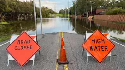
The remnants of Hurricane Harvey dumped roughly 50 inches of rain on parts of Houston over four days in August 2017, flooding more than 150,000 homes in that city alone, according to a city study. That study concluded that if all of Houston's homes had been compliant with the city's new rules, 84 percent of the city's homes that flooded during Harvey would have been spared.
Experts say that FEMA flood maps are not accurately assessing risk and that many maps are outdated. FEMA, however, argues that the maps are used for insurance purposes only, and it says it encourages cities to set their own higher standards.
FULL STORY: Not Trusting FEMA’s Flood Maps, More Storm-Ravaged Cities Set Tougher Rules

FEMA Flood Insurance Updates Reflect Actual Risk to Each Home
Changes to how FEMA calculates flood risk will assess risk at a home-by-home level, rather than estimating the same risk to all homes in the same floodplain.
FEMA Suspends Flood Rebuilding Standard
The rule was designed to prevent the rebuilding of government-funded projects in areas prone to repeated floods.

Floodplain Development Largely Concentrated in Gulf Coast States
Many U.S. cities use ‘routine’ practices like zoning changes and permitting to discourage development in high-risk flood zones.

Montreal Mall to Become 6,000 Housing Units
Place Versailles will be transformed into a mixed-use complex over the next 25 years.

Planetizen Federal Action Tracker
A weekly monitor of how Trump’s orders and actions are impacting planners and planning in America.

DARTSpace Platform Streamlines Dallas TOD Application Process
The Dallas transit agency hopes a shorter permitting timeline will boost transit-oriented development around rail stations.

Nine Ways to Use Curb Space That Aren’t Parking
California’s new daylighting law bans parking within 20 feet of crosswalks. How can cities best use this space?

ADUs for Sale? San Diego Could Legalize Backyard Condos
As one of 25 proposed amendments, San Diego may soon allow accessory dwelling units to be bought and sold as individual homes.

Dallas Ditches Parking Minimums in 14-1 Vote
The sweeping city council decision removes set parking requirements from developments downtown, near transit, small businesses and more.
Urban Design for Planners 1: Software Tools
This six-course series explores essential urban design concepts using open source software and equips planners with the tools they need to participate fully in the urban design process.
Planning for Universal Design
Learn the tools for implementing Universal Design in planning regulations.
City of Mt Shasta
City of Camden Redevelopment Agency
City of Astoria
Transportation Research & Education Center (TREC) at Portland State University
City of Camden Redevelopment Agency
Municipality of Princeton (NJ)
Regional Transportation Commission of Southern Nevada