


Liberty Street was once a narrow, urban street. Now it's seven lanes of unsafe speeds and pedestrian risks. The city has a plan to greatly reduce the number of traffic lanes on the street, or another plan that won't.
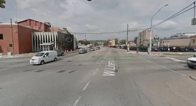
"A years-in-the-making redesign of Liberty Street -- one of Cincinnati's most vital and heavily-traveled roads -- might have taken one step closer to reality this week," reports Pat LaFleur.
Or not. There is plenty of reason to be skeptical about the likelihood of the project ever reaching completion, according to LaFleur. Local residents have been calling for the road diet to reduce speeds and increase safety for all users for years. According to data from the Cincinnati Police Department, Liberty Street has seen 1,700 traffic collisions since 2013, 30 involving pedestrians.
The city is currently considering two plans for the seven-lane street. One is the "road diet" configuration, which would shrink the road to five vehicle travel lanes. That alternative has support from a supermajority of Cincinnati councilmembers. The other planwould preserve all seven vehicle travel lanes, but add bump-outs at six intersections along the street. That plan has the support of Mayor John Cranley.
"The biggest conflict still stirring among lawmakers centers around what is a perpetual challenge for Over-the-Rhine: on-street parking," according to LaFleur. "Cranley's argument -- as well as several speakers at Monday's hearing -- is that the neighborhood cannot afford to lose all-day on-street parking."
FULL STORY: Will Liberty Street ever get its 'road diet'?


Planning for Congestion Relief
The third and final installment of Planetizen's examination of the role of the planning profession in both perpetuating and solving traffic congestion.
How Planning Fails to Solve Congestion
Solutions for congestion are never as simple and easy as armchair planners and engineers would like you to believe—especially those who suggest that congestion can be solved by forever building more roadway capacity.

Planning and the Complicated Causes and Effects of Congestion
What do planners know about congestion, and what can they do about it? Explanations and solutions are less obvious than they seem (part one of a three-part series).

Planetizen Federal Action Tracker
A weekly monitor of how Trump’s orders and actions are impacting planners and planning in America.

Congressman Proposes Bill to Rename DC Metro “Trump Train”
The Make Autorail Great Again Act would withhold federal funding to the system until the Washington Metropolitan Area Transit Authority (WMATA), rebrands as the Washington Metropolitan Authority for Greater Access (WMAGA).

DARTSpace Platform Streamlines Dallas TOD Application Process
The Dallas transit agency hopes a shorter permitting timeline will boost transit-oriented development around rail stations.

Supreme Court Ruling in Pipeline Case Guts Federal Environmental Law
The decision limits the scope of a federal law that mandates extensive environmental impact reviews of energy, infrastructure, and transportation projects.

Texas State Bills to Defund Dallas Transit Die
DART would have seen a 30% service cut, $230M annual losses had the bills survived.

Bikeshare for the Win: Team Pedals to London Cricket Match, Beats Rivals Stuck in Traffic
While their opponents sat in gridlock, England's national cricket team hopped Lime bikes, riding to a 3-0 victory.
Urban Design for Planners 1: Software Tools
This six-course series explores essential urban design concepts using open source software and equips planners with the tools they need to participate fully in the urban design process.
Planning for Universal Design
Learn the tools for implementing Universal Design in planning regulations.
Roanoke Valley-Alleghany Regional Commission
City of Mt Shasta
City of Camden Redevelopment Agency
City of Astoria
Transportation Research & Education Center (TREC) at Portland State University
US High Speed Rail Association
City of Camden Redevelopment Agency
Municipality of Princeton (NJ)