


Chicago is the home of a political movement to protect birds from the hazards presented by glass-sheathed modern buildings.
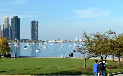
Blair Kamin reports on two new pieces of legislation, both originating from Chicago-area elected officials, to require bird-safe construction on new buildings.
Ald. Brian Hopkins, 2nd, proposed a local ordinance in January called the Bird Friendly Design ordinance, with backing from a coalition of groups calling itself Bird Friendly Chicago.
Quigley’s legislation, the Bird-Safe Buildings Act, would apply to public buildings constructed, significantly renovated or bought by the U.S. General Services Administration, the federal government’s landlord.
Kamin explains some of the details of that proposed local ordinance:
One of its measures would mandate that at least 95 percent of a building’s facade, from the ground to a height of 36 feet, not be sheathed in glass or have bird-safe glass with etching, frosting or mounted elements like screens.
Another item in the proposed ordinance would require that nonessential exterior lighting be automatically shut off between 11 p.m. and sunrise. Interior landscaping should “always” be placed behind bird-friendly exterior glass, the proposal says.
Rep. Mike Quigley (D-Ill) has proposed a separate piece of legislation at the federal level called the Bird-Safe Buildings Act that "would apply to public buildings constructed, significantly renovated or bought by the U.S. General Services Administration, the federal government’s landlord."
FULL STORY: Spectacular skylines can also be bird killers. Here's how a proposed Chicago ordinance is trying to help.


New York Largest U.S. City to Require Bird-Friendly Building Materials
The New York City Council approved Proposed Initiative 1482B by an overwhelming margin, ensuring bird-friendly design and construction practices in the largest U.S. city.
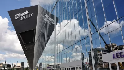
U.S. Bank Stadium: Home to Super Bowl LII and a Death Trap for Migratory Birds
This isn't a joke about the Philadelphia Eagles. This story is about the deadly consequences of planning and architecture decisions.
State Bill Would Add TIFs Along Transit Lines in Chicago
Expanded use of tax increment financing is on the table in Chicago—a city that invests less than its peers on building and running transit.

Planetizen Federal Action Tracker
A weekly monitor of how Trump’s orders and actions are impacting planners and planning in America.

Congressman Proposes Bill to Rename DC Metro “Trump Train”
The Make Autorail Great Again Act would withhold federal funding to the system until the Washington Metropolitan Area Transit Authority (WMATA), rebrands as the Washington Metropolitan Authority for Greater Access (WMAGA).

DARTSpace Platform Streamlines Dallas TOD Application Process
The Dallas transit agency hopes a shorter permitting timeline will boost transit-oriented development around rail stations.

San Francisco's School District Spent $105M To Build Affordable Housing for Teachers — And That's Just the Beginning
SFUSD joins a growing list of school districts using their land holdings to address housing affordability challenges faced by their own employees.

Car-Centric LA Suburb Looks to a Train-Oriented Future
City leaders in Rancho Cucamonga, the future western terminus of the Brightline West rail line to Las Vegas, want to reimagine the city as a transit-oriented, pedestrian-friendly community.

New Alaska Bitcoin Mine Would Burn as Much Energy as the State’s Largest Coal Plant
Fueled by “stranded” natural gas, the startup hopes to become the largest in the US, and to make Alaska an industry center.
Urban Design for Planners 1: Software Tools
This six-course series explores essential urban design concepts using open source software and equips planners with the tools they need to participate fully in the urban design process.
Planning for Universal Design
Learn the tools for implementing Universal Design in planning regulations.
Municipality of Princeton
Roanoke Valley-Alleghany Regional Commission
City of Mt Shasta
City of Camden Redevelopment Agency
City of Astoria
Transportation Research & Education Center (TREC) at Portland State University
US High Speed Rail Association
City of Camden Redevelopment Agency
Municipality of Princeton (NJ)