


The city will reduce vehicle lanes and build a protected multi-use trail including bioswales and other water retention features on its ‘secret highway.’
An underused stretch of a Milwaukee road will be transformed into “an environmentally and people-friendly corridor,” writes Jeramey Jannene in Urban Milwaukee.
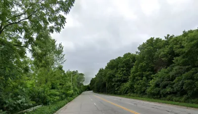
The strip is located on 1st Street, sandwiched between the Kinnickinnic River and a steep hill. As Jannene explains, “There are no sidewalks or pedestrian accommodations to be found on the approximately half-mile, four-lane stretch, and there is little traffic. There are no homes or businesses. The only driveway is a chained-off ramp to a Deep Tunnel access point.” Now, the city has announced it will reduce vehicle lanes from four to two and add a 10-foot-wide pedestrian and bike path and bioswale.
The design will increase safety for pedestrians and cyclists and also improve drainage by reducing paved surface area. “The bioswales and other environmental features are expected to add almost 91,000 gallons of storm water storage capacity, and 40 trees are expected to be planted.”
The project is funded in part by grants from the Milwaukee Metropolitan Sewerage District and the National Fish and Wildlife Foundation’s Sustain Our Great Lakes program.
FULL STORY: Milwaukee Will Shrink Its Secret Highway

Indy Neighborhood Group Builds Temporary Multi-Use Path
Community members, aided in part by funding from the city, repurposed a vehicle lane to create a protected bike and pedestrian path for the summer season.
Milwaukee Announces 60 Traffic Calming Projects for 2025
The city has successfully reduced traffic deaths and aims to eliminate them completely within the next decade.
Milwaukee Traffic Safety Projects To Receive $8.5 Million in TIF Funds
The city hopes to combat a growing reckless driving 'crisis' with traffic calming, bike lanes, and other projects aimed at improving roadway safety.

Maui's Vacation Rental Debate Turns Ugly
Verbal attacks, misinformation campaigns and fistfights plague a high-stakes debate to convert thousands of vacation rentals into long-term housing.

Planetizen Federal Action Tracker
A weekly monitor of how Trump’s orders and actions are impacting planners and planning in America.

San Francisco Suspends Traffic Calming Amidst Record Deaths
Citing “a challenging fiscal landscape,” the city will cease the program on the heels of 42 traffic deaths, including 24 pedestrians.

Defunct Pittsburgh Power Plant to Become Residential Tower
A decommissioned steam heat plant will be redeveloped into almost 100 affordable housing units.

Trump Prompts Restructuring of Transportation Research Board in “Unprecedented Overreach”
The TRB has eliminated more than half of its committees including those focused on climate, equity, and cities.

Amtrak Rolls Out New Orleans to Alabama “Mardi Gras” Train
The new service will operate morning and evening departures between Mobile and New Orleans.
Urban Design for Planners 1: Software Tools
This six-course series explores essential urban design concepts using open source software and equips planners with the tools they need to participate fully in the urban design process.
Planning for Universal Design
Learn the tools for implementing Universal Design in planning regulations.
Heyer Gruel & Associates PA
JM Goldson LLC
Custer County Colorado
City of Camden Redevelopment Agency
City of Astoria
Transportation Research & Education Center (TREC) at Portland State University
Jefferson Parish Government
Camden Redevelopment Agency
City of Claremont