


Bike lanes delineated with bollards or traffic cones are most likely to slow drivers and reduce crashes between cars and bikes.
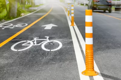
A study of temporary bike lanes installed at an intersection in Asbury Park, New Jersey shows that both painted and delineated bike lanes (those separated with bollards) slow drivers and reduce the risk of collisions with people on bikes.
As Maylin Tu explains in Next City, “For the experiment, researchers temporarily removed nine parking spaces to create 6-foot wide bike lanes with a 3-foot buffer between bike and car travel lanes. Car travel lanes were reduced by at least one foot each, a decrease that has been shown to reduce crashes. In addition, the bike lanes created a sharper turning radius for drivers turning right, another intervention that might force drivers to slow down.”
Delineated lanes made the biggest impact. “For vehicles turning right, top speeds were reduced by 28% and average speeds by 21%. Paint-only bike lanes slowed driver speeds by up to 14% and drivers going straight slowed down by up to 8%.”
The study notes that pop-up, temporary bike lanes like the ones used in the research can help cities understand how bike lanes can improve road safety before making more permanent changes, but “In order to achieve Vision Zero initiatives, planners and policy makers should focus efforts on delineated bike lanes, not merely painted lanes.”
FULL STORY: How Bike Lanes Slow Drivers and Save Lives

Austin Outlaws Blocking Bike Lanes
Drivers who park in bike lanes will receive citations of up to $300.
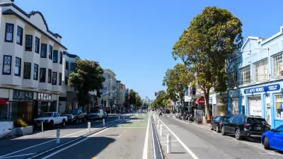
How San Francisco’s ‘People Protected Bike Lanes’ are Moving the Needle on Road Safety
A local bike safety protest has become a global phenomenon.
NACTO Releases Updated Urban Bikeway Guide
The third edition of the nationally recognized road design guide includes detailed design advice for roads that prioritize safety and accessibility for all users.

Maui's Vacation Rental Debate Turns Ugly
Verbal attacks, misinformation campaigns and fistfights plague a high-stakes debate to convert thousands of vacation rentals into long-term housing.

Planetizen Federal Action Tracker
A weekly monitor of how Trump’s orders and actions are impacting planners and planning in America.

Chicago’s Ghost Rails
Just beneath the surface of the modern city lie the remnants of its expansive early 20th-century streetcar system.

Bend, Oregon Zoning Reforms Prioritize Small-Scale Housing
The city altered its zoning code to allow multi-family housing and eliminated parking mandates citywide.

Amtrak Cutting Jobs, Funding to High-Speed Rail
The agency plans to cut 10 percent of its workforce and has confirmed it will not fund new high-speed rail projects.

LA Denies Basic Services to Unhoused Residents
The city has repeatedly failed to respond to requests for trash pickup at encampment sites, and eliminated a program that provided mobile showers and toilets.
Urban Design for Planners 1: Software Tools
This six-course series explores essential urban design concepts using open source software and equips planners with the tools they need to participate fully in the urban design process.
Planning for Universal Design
Learn the tools for implementing Universal Design in planning regulations.
planning NEXT
Appalachian Highlands Housing Partners
Mpact (founded as Rail~Volution)
City of Camden Redevelopment Agency
City of Astoria
City of Portland
City of Laramie