


A new bus line will bring some of the benefits of bus rapid transit, connecting the city’s airport and downtown.
An article by Andrea Drusch in the San Antonio Report describes how a future Advanced Rapid Transit (ART) line will operate once it opens in 2027.
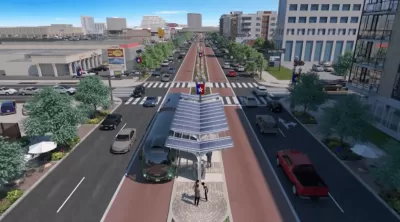
The north-south Green Line is part of VIA Metropolitan Transit’s plans to bring more rapid transit to San Antonio and will connect the international airport to the city’s downtown and colonial-era missions.
“The first segment was made possible by a windfall of pandemic relief money for VIA, combined with a voter-approved one-eighth-cent sales tax for transit that starts in 2026. The agency has used some of its $270 million in pandemic relief to move the project along before the tax increment funding kicks in, while the approval of a local match allowed VIA to leverage federal money for the rest.”
The line will have dedicated center lanes in some areas and will pick up passengers from the outermost traffic lanes in others. “To reduce stop times, riders are expected to pay for the fare in advance, possibly by mobile app. No ticket will be required to board. Raised boarding platforms also will minimize stop times, allowing buses to run at more frequent, predictable intervals.” The project also includes funding for new sidewalks and pedestrian crossing improvements.
The project is hindered by conflict with the Texas Department of Transportation (TxDOT), Drusch adds. “Notably, the Green Line buses must run alongside regular traffic when passing under highways, where the state retains the right-of-way.”
FULL STORY: Hop on the Green Line: How VIA’s new rapid bus route will operate

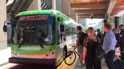
State Bill Could Kill Indy BRT Line
A law proposed in the Indiana state legislature would ban dedicated bus lanes and force IndyGo to cancel a planned bus rapid transit line to the city's airport.
Madison BRT a Midwest Rarity
Despite the benefits, just three Midwestern cities have bus rapid transit lines.
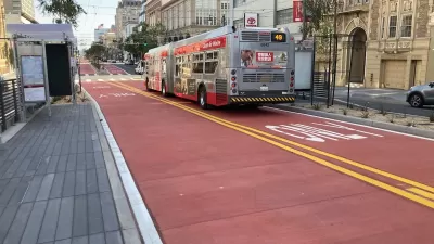
Van Ness BRT Speeds Travel by 36%, Earns Silver Designation
The San Francisco rapid bus line is making transit on the corridor more reliable and reducing traffic crashes and congestion.

Planetizen Federal Action Tracker
A weekly monitor of how Trump’s orders and actions are impacting planners and planning in America.

Chicago’s Ghost Rails
Just beneath the surface of the modern city lie the remnants of its expansive early 20th-century streetcar system.

San Antonio and Austin are Fusing Into one Massive Megaregion
The region spanning the two central Texas cities is growing fast, posing challenges for local infrastructure and water supplies.

Since Zion's Shuttles Went Electric “The Smog is Gone”
Visitors to Zion National Park can enjoy the canyon via the nation’s first fully electric park shuttle system.

Trump Distributing DOT Safety Funds at 1/10 Rate of Biden
Funds for Safe Streets and other transportation safety and equity programs are being held up by administrative reviews and conflicts with the Trump administration’s priorities.

German Cities Subsidize Taxis for Women Amid Wave of Violence
Free or low-cost taxi rides can help women navigate cities more safely, but critics say the programs don't address the root causes of violence against women.
Urban Design for Planners 1: Software Tools
This six-course series explores essential urban design concepts using open source software and equips planners with the tools they need to participate fully in the urban design process.
Planning for Universal Design
Learn the tools for implementing Universal Design in planning regulations.
planning NEXT
Appalachian Highlands Housing Partners
Mpact (founded as Rail~Volution)
City of Camden Redevelopment Agency
City of Astoria
City of Portland
City of Laramie